The Dictionary of Sydney was archived in 2021.
The Dictionary of Sydney was archived in 2021.
Dawes Point
Citation
Persistent URL for this entry
To cite this entry in text
To cite this entry in a Wikipedia footnote citation
To cite this entry as a Wikipedia External link
Dawes Point
The promontory at the western end of Circular Quay was known to the Aboriginal people as Tar-Ra. It was chosen as the site for an observatory by Lieutenant William Dawes, who arrived with the first Europeans. Dawes came with a recommendation from the Astronomer Royal, Dr Nevil Maskelyne, and some instruments from the Board of Longitude, with which to study the heavens. The point was initially named Maskelyne Point, but as Dawes lived there while he was in the colony from 1788 until 1791, the area became known as Dawes Point.
Dawes kept the colony's first meteorological records here, and it was also here that Dawes pinned the town's first clock to a rock face. He encouraged friendship with local Aboriginal people, including a young girl Patyegarang, from whom he learned some of the language of the Cadigal people. Dawes's notebooks, held in the School of Oriental and African Studies at the University of London, remain one of the most precious records of the local language. [1]
Sydney's first observatory
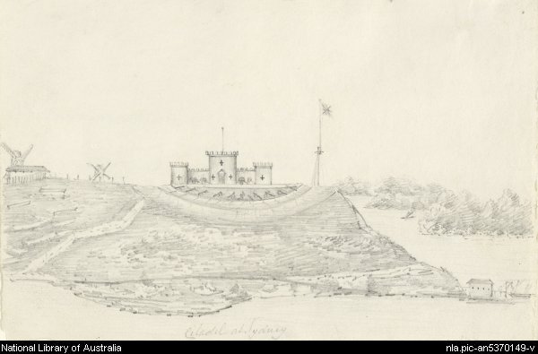
The 'Observatory' was a simple timber and shingle cottage. A powder magazine and primitive fort and gun emplacement were built not long after, though these soon fell into disrepair. In 1819 Francis Greenway designed a castellated fort to replace the earlier structure, as part of the defences of the town. The fortunes of the harbour fortifications waxed and waned with changing perceptions of external threats, and following several upgrades this fort was eventually rendered obsolete by [media]fortifications closer to the harbour heads.
The control of defence sites was handed over to the federal government following Federation, but Dawes Point was excepted as it clearly no longer had any real defence function. Because of its position, it has long been a popular spot from which to watch harbour regattas and fireworks displays.
The bridge
In 1925 part of the fort was demolished, while part was used by the British firm Dorman & Long, builders of the Sydney Harbour Bridge. The bridge required the demolition of several rows of nearby houses as well, and once the bridge was built, the area below it became Dawes Point Park. Lower Fort Street, facing west Circular Quay, was once one of Sydney's premier streets. It ended up almost under the bridge, and the inhabitants of its large fine houses, now mostly offices or subdivided into flats, need to suspend conversation whenever a train rumbles over the bridge.
Up until 1906, a cannon was fired at Dawes Point every day at 1 pm – a useful marker of time for the town. The cannon was removed during the construction of the bridge, but replaced in the park in 1945.
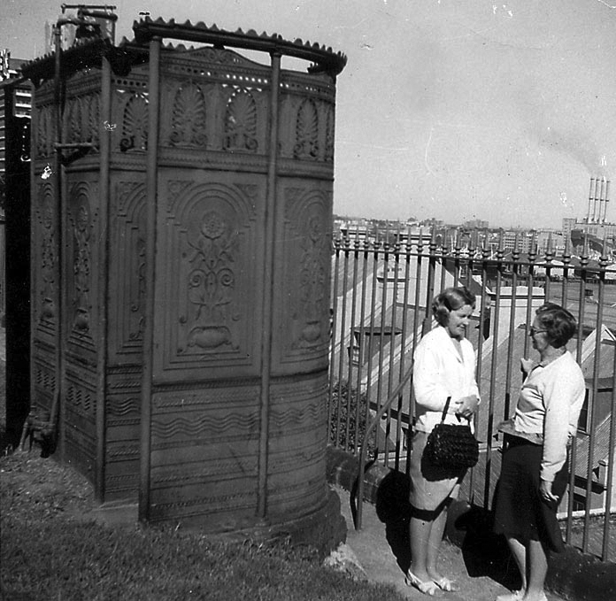
One of the [media]curiosities of the area is a much photographed 1880s cast iron urinal. It originally stood on Observatory Hill, but when the Sydney City Council removed it and proposed selling it off in the 1970s, there was a barrage of protest. Eventually the urinal reappeared in George Street, under the bridge. This location is also famous in working-class memory as one of the major pick-up points for wharfies who would assemble here and hope that their number would be called out, providing them with work on ships in port that day.
Dawes Point today
Between 1995 and 2000 the Sydney Cove Authority (currently the Sydney Harbour Foreshore Authority) undertook archaeological research in the park. The results contributed to an onsite interpretation of the earlier structures and functions of the land.
Dawes Point and the Sydney Harbour Bridge divide the Rocks area from Millers Point, and the surrounding houses have historically been known as part of either or both precincts. To further complicate the nomenclature, a few of these streets were gazetted as Dawes Point on 16 April 1993.
In 2002 the promontory of Dawes Point was formally dual-named by the Geographic Names Board as Dawes Point–Tar-Ra.
Notes
[1] Extracts published in William Marsden, Miscellaneous Works of William Marsden, Parbury, Allen & Co, London, 1834


