The Dictionary of Sydney was archived in 2021.
The Dictionary of Sydney was archived in 2021.
Atlas of the Suburbs of Sydney
Citation
Persistent URL for this entry
To cite this entry in text
To cite this entry in a Wikipedia footnote citation
To cite this entry as a Wikipedia External link
Atlas of the Suburbs of Sydney
[media]The Atlas of the Suburbs of Sydney is a series of late-nineteenth-century commercial maps that provides a portrait of the city during a period of rapid growth and suburbanisation. The maps are also evidence of one of the recurring themes of the mapping of Australia — the inability of government surveys and mapping to keep pace with demand for land acquisition. As Sydney expanded and new municipalities were created, the need for simple, informative area and street maps grew and the Atlas maps were produced by commercial map makers to meet this need.
The Atlas of the Suburbs of Sydney was created by Higinbotham, Robinson and Harrison, map publishers and lithographers established in 1882 with premises in Macquarie Place. They had obtained permission to produce maps from government survey information and were able to advertise maps that had been 'compiled from official plans in the Surveyor-General and Registrar-General's offices'. [1]
On 22 December 1885 the publication of the Atlas was announced in the Sydney Morning Herald:
Messrs Higinbotham, Robinson and Harrison, map publishers, of 99, Pitt-Street, have just issued 'Part 1' of an Atlas of the suburbs of Sydney, containing maps of the boroughs of Ashfield, Balmain, Leichhardt, Marrickville, Petersham, and St Peters, printed in colours, distinctly showing the wards within each. Taking the map of Balmain as an example, all the streets and lanes are shown, also public buildings, reserves, wharves, and public baths, names of bays and points, connecting bridges, adjacent islands, and adjoining boroughs. Upon the front cover appear views of four suburban town halls. The inner side contains a calendar of 1886, and upon the next page 'municipal statistics' are given in a tabulated form, comprising the date of incorporation, area, miles of streets opened to traffic, the number of buildings and ratepayers, amount of rates for 1885, annual value of rateable property, population, number of alderman in each borough, council meetings, etc. These statistics have been supplied by the councils to the publishers, with the exception of the areas, which have been calculated from actual measurements plotted by the publishers. Balmain was originally a crown grant of 640 acres [259 hectares], but now actually contains 866 acres [350 hectares], including reclamations. An index map, showing the relative position of the boroughs to each other, and to the city of Sydney, is printed upon the back cover. Taken all together the atlas is a creditable production. Additionalar [sic] parts are to be published until the remainder of the suburbs have been completed. They are contemporaneous with a very large map which is being prepared of the city and suburbs, extending to Georges River, Homebush, Hunters Hill, and Manly, as rapidly as private and official surveys will permit. [2]
The announcement outlines an ambitious publishing program, but the subsequent issue of additional maps is difficult to trace and the fortunes of the company declined. In 1887 Harrison withdrew from the partnership and although in October of that year John Sands was asked to quote on printing and binding six maps to form part two of the Atlas it is not clear if it was produced. [3] In April 1888 Higinbotham and Robinson was declared bankrupt. Among the assets listed for sale were a stock of maps and the rights to 21 real estate maps of municipalities, which presumably represents the firm's output to this time. [4]
After being discharged from bankruptcy Higinbotham and Robinson continued in business together and by 1891 they were operating from 62 Elizabeth Street and nearby Wentworth Court. In 1895 Herbert Robinson set up on his own, operating as HEC Robinson, and developed a very successful business publishing maps and directories until his death in 1933.
Examples of the Atlas maps survive in several collections. The copies reproduced here are from the City of Sydney Archives and these have been digitised and made available as part of the online Historical Atlas of Sydney. [5] The Archives collection includes a bound set of the Atlas maps containing 51 sheets although the binding does not include the original covers and was probably done by the council. [6] The sheets have been numbered in red ink to provide an index for the set. In several cases a later version of a map has been added to the series by inserting it in front of the original map, in other cases maps exhibit overprinting that updates the original.
Surviving copies show that the 1885 maps were originally bound in a folder with rigid covers about 250 by 375 mm as described in the newspaper announcement. The elaborate decoration of these covers expresses the exuberant style associated with the 1880s boom period that was soon to be cut short by the economic depression of the early 1890s. In addition to the title and other details, the cover is adorned with four insets showing Ashfield School of Arts and Council Chambers, Marrickville Town Hall, Burwood School of Arts and Council Chambers and Petersham Town Hall. The inside front cover has a calendar for 1886 and an advertisement for Batson and Company, printers, of 195 Clarence Street, including a note to say that the advertisements in the Atlas were printed by Batson and Company.
The inside [media]back cover displayed a list of maps published by Higinbotham, Robinson and Harrison. These are maps of the Parish of St George and the municipalities of Canterbury, Ashfield, Burwood and Balmain at scales and levels of detail much greater than the small Atlas maps. Also listed are maps of the Pennant Hills district, a street and locality map of the North Shore, a yachting and excursion map of Port Jackson and a map of the Clarence–New England and Macleay River pastoral districts. At the base of the page the firm declares:
We are in readiness to receive orders from suburban municipal councils for maps of their respective boroughs.
The back cover was largely taken up with a description of the business and a sketch plan showing the locations of the municipalities in the Atlas. At the base is an advertisement for John Sands, the well-known Sydney printer and stationer.
The maps that the company had produced between 1882 and 1885, listed inside the back cover, are substantial undertakings containing a wealth of information about streets and localities as well as the complex detail needed to record land ownership and subdivisions. These maps would have had a fairly limited market. It seems possible that these complex productions were straining the company's resources and that the production of the Atlas, with many much smaller and simpler maps that would appeal to a much wider audience, was designed to both fill a need and make people aware of their higher quality products.
Part one of the Atlas, containing six small municipal maps, cost seven shillings and sixpence whereas a basic copy of the municipality of Canterbury map cost 34 shillings and sixpence, more than four times as much.
The maps
The name of the Atlas is somewhat misleading; it refers to suburbs but in fact the maps are of municipalities. The City of Sydney was the first local government area created in New South Wales in 1842. Later municipal councils were constituted under successive laws that used a variety of terms, including borough, district and municipality. While these terms appear in historical documents, it is appropriate to refer to all local government areas as municipalities.
The title of each map includes a reference to the parish or parishes within which the municipality is located. These parishes relate to the system of recording land ownership established in 1835 and not to religious parishes. However some of the names of these secular parishes, such as St Philip, St James and St Lawrence in central Sydney and St John at Parramatta, coincide with the early religious parishes in the same location.
The majority of the maps use one of several variants of a north arrow that includes the monogram HR (for Higinbotham and Robinson) inside a conventional garter band with the Latin motto fiat lux. This phrase from the Vulgate Bible (Genesis 1:3) is normally translated as 'let there be light' and is used commonly to suggest the pursuit or sharing of knowledge.
The address printed on the maps and the variations in the style of north arrow, border and other details make it possible to give date ranges to the maps. Only one of the maps discussed here has a company name listing the three partners, it is one of the six originally issued in 1885 but has been overprinted. With this single exception, all of the maps fall into two groups: those associated with the 99 Pitt Street address from late 1886 to 1888 and those associated with the Elizabeth Street–Wentworth Court addresses used from 1889 to 1894.
Each map has a bar scale graduated in the old customary units of chains, miles and occasionally feet. The chain was a standard traditional surveying unit of 22 yards (20.1168 metres). The scale of the maps in the series varies in order to show the different-sized municipalities on the same standard sheet. These scales range from about 1:4000 to 1:40000, with the majority at quite large scales. For comparison, modern street directories are likely to use a scale of 1:5000 for detailed maps of city centres and 1:20000 for suburban areas. With the difference in scale comes a difference in the level of detail shown on the maps. The larger scale maps identify many features and individual buildings, while at smaller scales only roads and major features are shown. As is normal with street directory maps the road network is often not shown precisely to scale but with roads wide enough to carry names. The maps also vary in accuracy and some have significant errors, no doubt because of incomplete or inaccurate surveys of the areas represented.
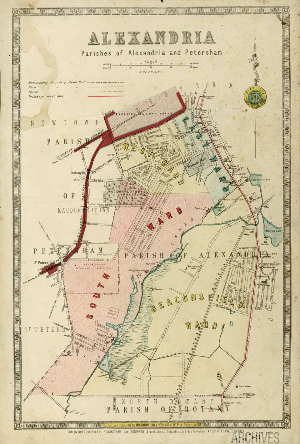
Alexandria, parishes of Alexandria and Petersham
[media]This map shows the municipality of Alexandria with its three wards at a scale of 1:11880 (1 inch equals 15 chains) and it was published between 1886 and 1888.
Alexandria was constituted in 1868 with an area of 4.2 square kilometers, which includes the modern suburbs of Alexandria and Beaconsfield and parts of Eveleigh, St Peters and Erskineville. In 1908 part of the municipality was merged with Erskineville and the remainder was incorporated into the City of Sydney in 1948.
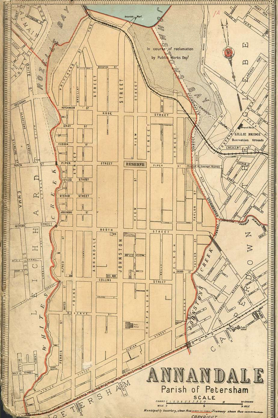
Annandale, parish of Petersham
[media]This map shows the municipality of Annandale at a scale of 1:6336 (1 inch equals 8 chains). It was probably published about 1894.
Annandale was constituted in 1894 – it had previously been the East Ward of Leichhardt municipality. It had an area of 1.4 square kilometres, almost the same as the modern suburb except for a small triangular area in the south-east between Johnstons Creek, Booth Street and Parramatta Road. In 1937 part of the municipality was combined with Sydney and in 1948 it was absorbed back into Leichhardt.
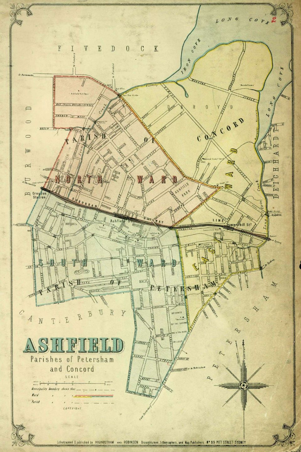
Ashfield, parishes of Petersham and Concord
[media]This map shows the municipality of Ashfield with its three wards at a scale of 1:15840 (1 inch equals 20 chains). Although Ashfield was included in the six maps that made up the first part of the Atlas, published in December 1885, this map was presumably reissued between 1886 and 1888.
Ashfield was constituted in 1871 with an area of 8.3 square kilometres, which includes the modern suburbs of Ashfield, Haberfield and Summer Hill, and parts of Croydon and Croydon Park.
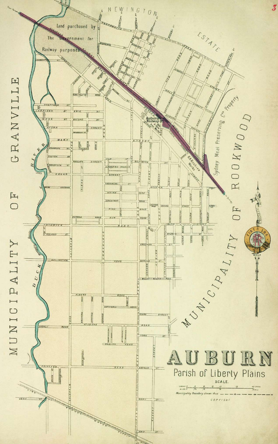
Auburn, parish of Liberty Plains
[media]This map shows the municipality of Auburn at a scale of 1:15840 (1 inch equals 20 chains). It was probably published between 1892 and 1894.
Auburn was constituted in 1892 with an area of 8.1 square kilometres, which coincides closely with the modern suburb of the same name except for the area north of Parramatta Road and the south-east corner which is part of Regents Park.
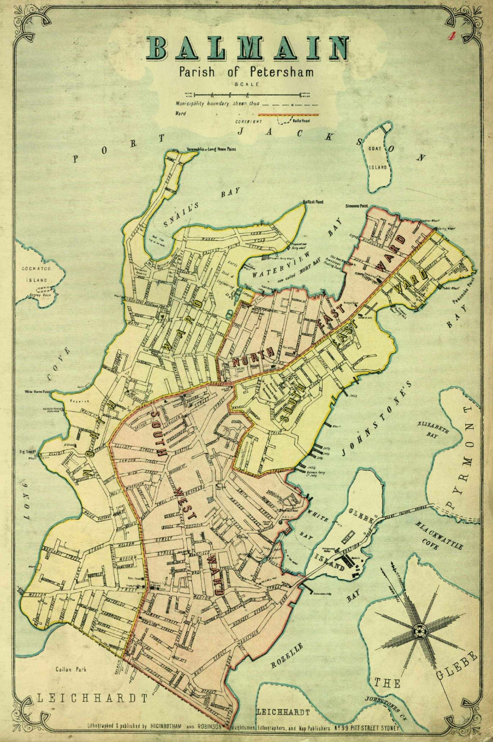
Balmain, parish of Petersham
[media]This map shows the municipality of Balmain with its four wards at a scale of 1:11880 (1 inch equals 15 chains). Although Balmain was included in the six maps that made up the first part of the Atlas, published in December 1885, this map was presumably reissued between 1886 and 1888.
Balmain was constituted in 1860 with an area of 3.8 square kilometres, occupying the whole of the peninsula and including the modern suburbs of Balmain, Balmain East, Birchgrove and Rozelle. In 1948 it was absorbed into the municipality of Leichhardt.
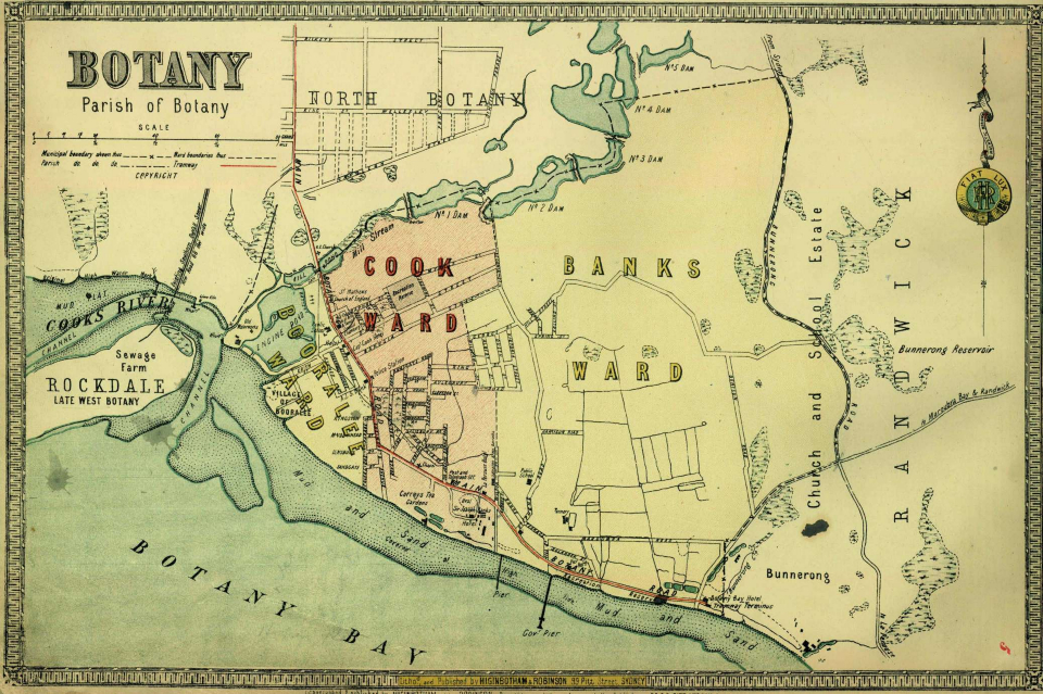
Botany, parish of Botany
[media]This map shows the municipality of Botany with its three wards at a scale of 1:19800 (1 inch equals 25 chains). It is likely to have been published in 1888.
Botany was constituted in 1888 with an area of 9.5 square kilometres, which includes the modern suburbs of Botany, Pagewood, Banksmeadow and Hillsdale. In 1996 it became part of the City of Botany Bay.
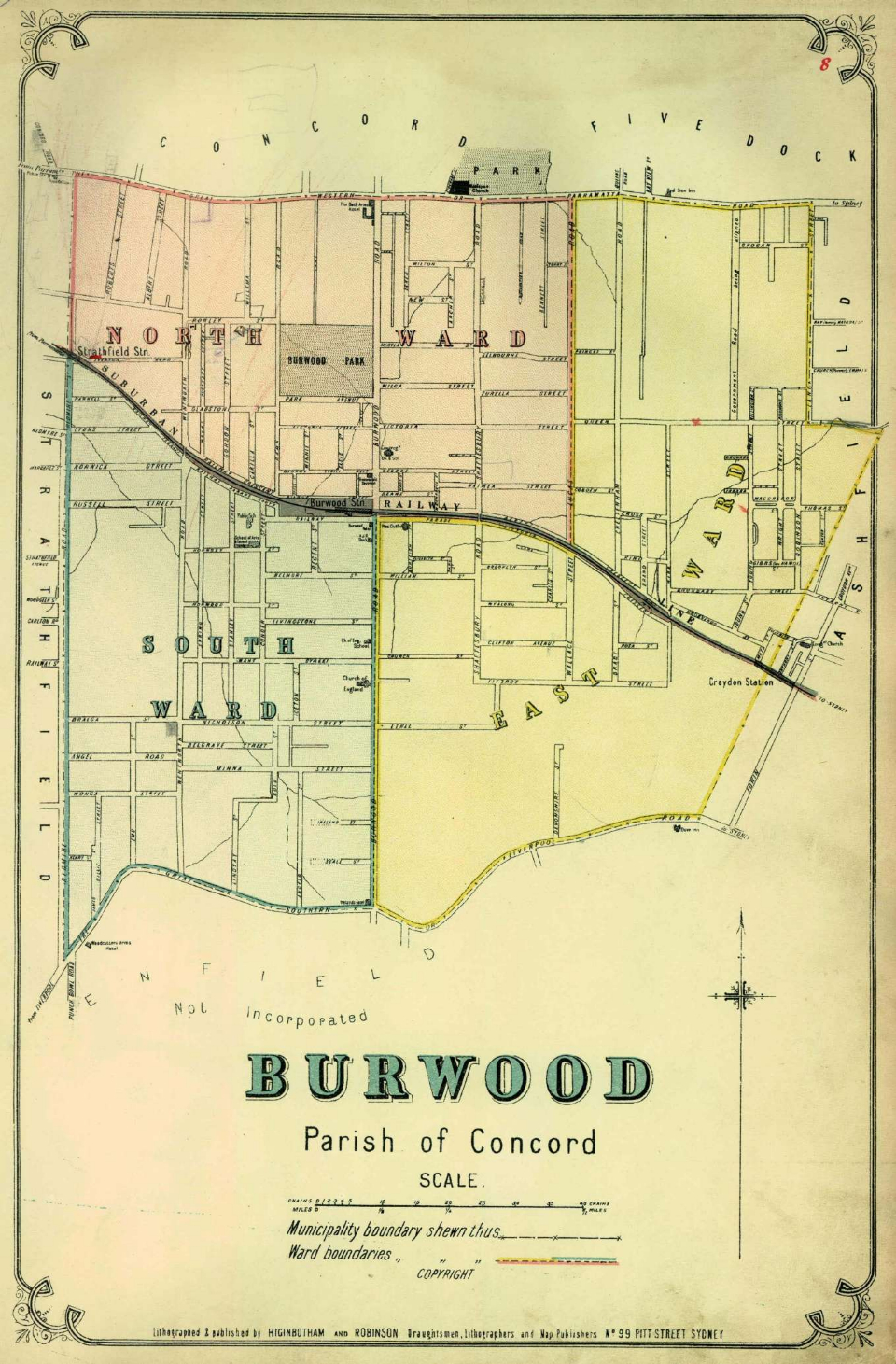
Burwood, parish of Concord
[media]This map shows the municipality of Burwood with its three wards at a scale of 1:11880 (1 inch equals 15 chains). It was probably published between 1886 and 1888.
Burwood was constituted in 1874 with an area of 4.4 square kilometres, which includes the modern suburbs of Burwood and parts of Strathfield and Croydon.
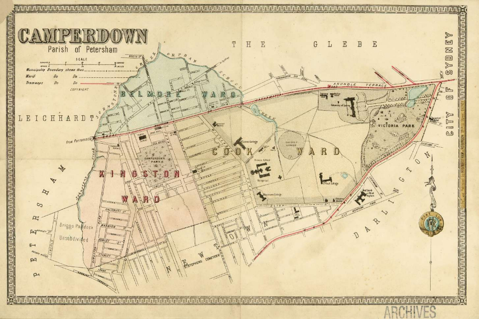
Camperdown, parish of Petersham
[media]This map shows the municipality of Camperdown with its three wards at a scale of 1:7920 (1 inch equals 10 chains). It was probably published between 1886 and 1888.
Camperdown was constituted in 1862 with an area of 1.6 square kilometres, which includes the modern suburbs of Camperdown and parts of Annandale, Newtown and Stanmore. In 1908 it was absorbed into the municipality of Marrickville.
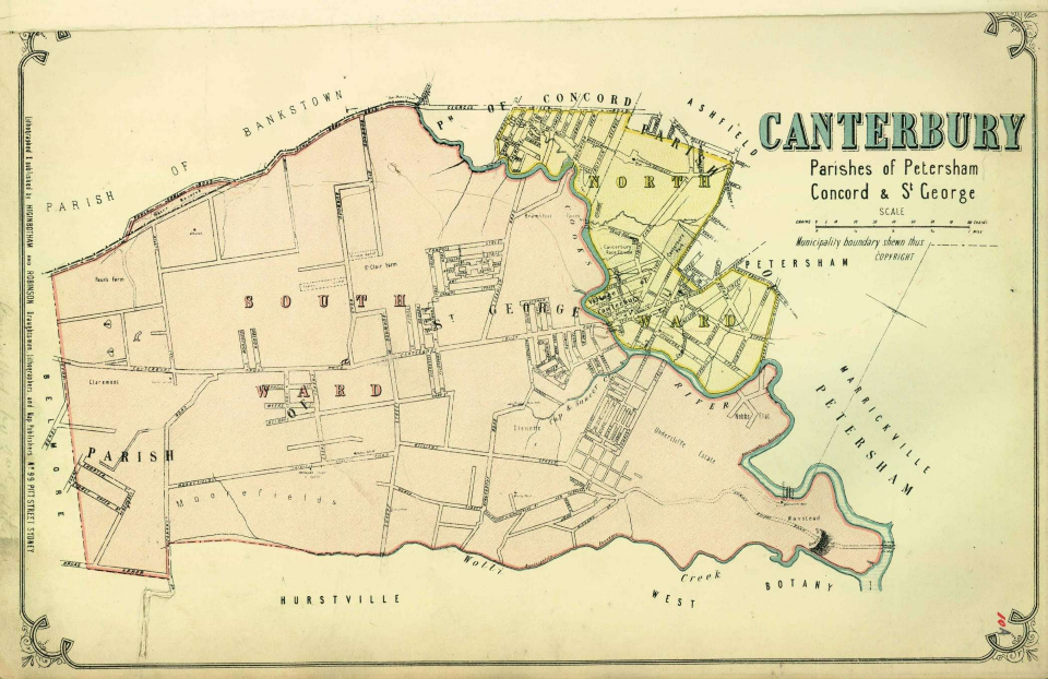
Canterbury, parishes of Petersham and St George
This is the [media]earlier of two maps of the municipality of Canterbury in this set. Both are at a scale of 1:31680 (1 inch equals 40 chains). They were probably published between 1886 and 1888.
Canterbury was constituted in 1879 with an area of 28.9 square kilometres, which includes the modern suburbs of Canterbury, Ashbury, Hurlstone Park, Earlwood, Belmore, Roselands, Wiley Park, Lakemba and parts of Croydon Park, Kingsgrove, Beverly Hills, Narwee, Punchbowl and Belfield.
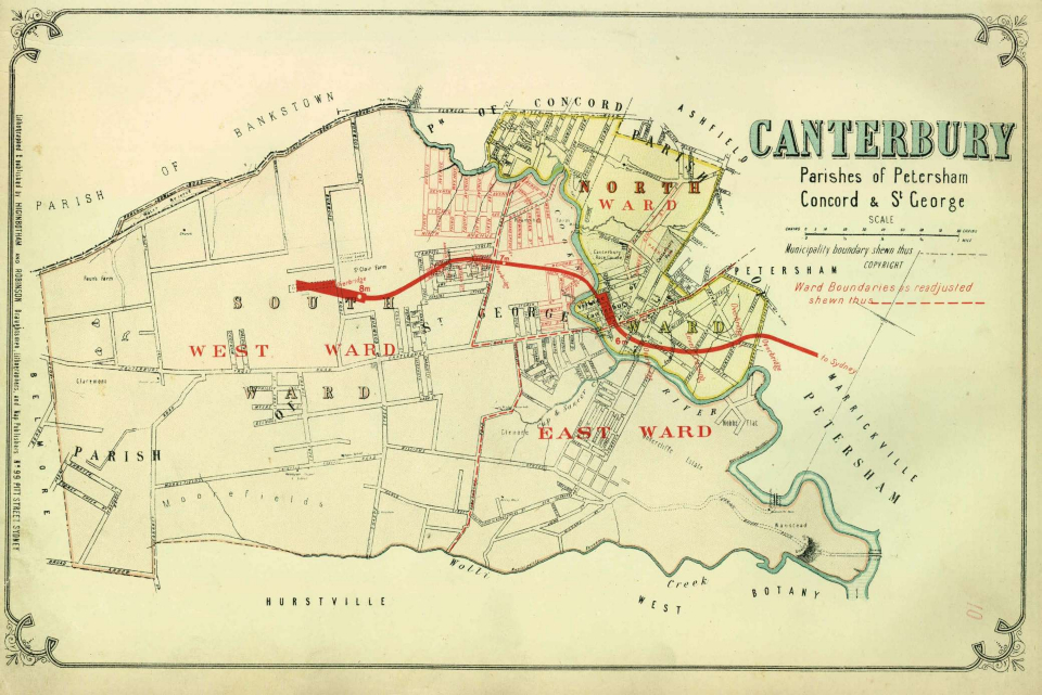
Canterbury, parishes of Petersham and St George
This is the [media]later of two maps of the municipality of Canterbury. This map is the same base as the earlier map but has overprinting in red. It was presumably published between 1888 and 1894.
The overprinting on this map shows an adjustment of the ward boundaries to create three wards and additional streets in the north-east of the municipality. It also shows the section of the Bankstown railway line from Sydenham to Belmore that opened in early 1895.
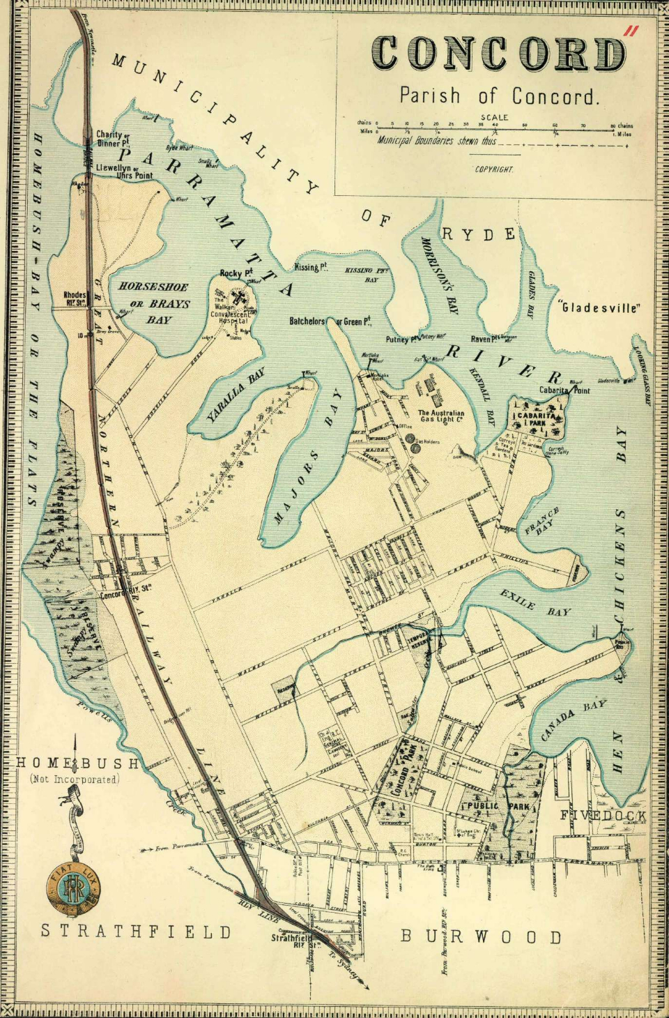
Concord, parish of Concord
This [media]map shows the municipality of Concord at a scale of 1:19800 (1 inch equals 25 chains). It was probably published between 1889 and 1894.
Concord was constituted in 1883 with an area of 11.6 square kilometres, which includes the modern suburbs of Concord, Mortlake, Breakfast Point, Cabarita, North Strathfield, Concord West, Liberty Grove and Rhodes.
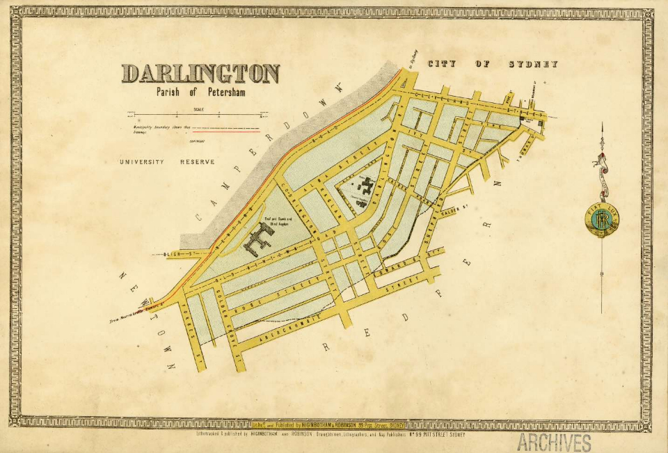
Darlington, parish of Petersham.
This map [media]shows the municipality of Darlington at a scale of 1:3960 (1 inch equals 5 approx chains). It was probably published between 1886 and 1888.
Darlington was constituted in 1864 with an area of 0.2 square kilometres, making it the smallest municipality in Sydney. It is included within the modern suburb of Darlington, except for the westernmost block between Golden Grove and Forbes streets.
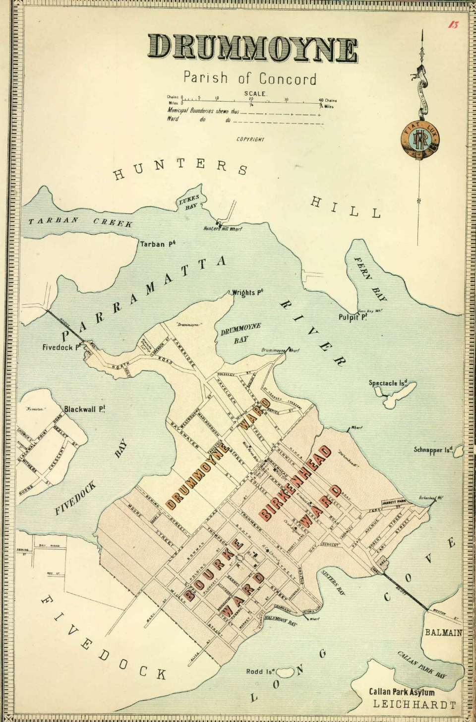
Drummoyne, parish of Concord
[media]This map shows the municipality of Drummoyne with its three wards at a scale of 1:11880 (1 inch equals 15 chains). It was probably published between 1889 and 1894.
Drummoyne was constituted in 1890 with an area of 2.3 square kilometres, occupying most of the peninsula and corresponding with the modern suburb of the same name. In 1902 Fivedock was absorbed by the municipality of Drummoyne, more than doubling its size.
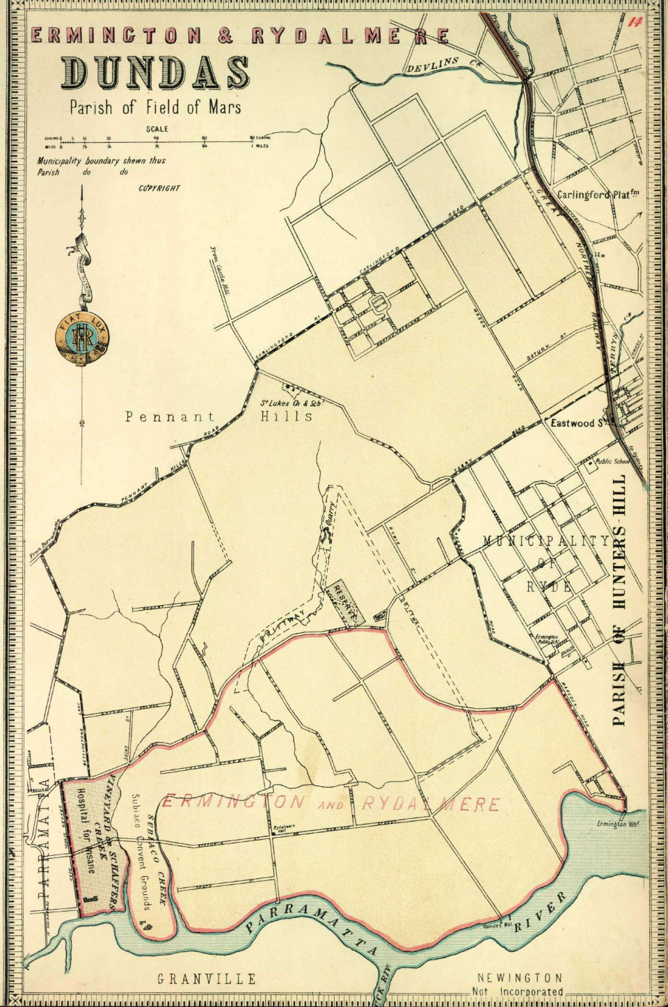
Dundas, parish of Field of Mars
This [media]map shows the municipality of Dundas at a scale of 1:23760 (1 inch equals 30 chains). The original version of this map was probably published between 1889 and 1891, and this version with overprinting was presumably published between 1891 and 1894.
Dundas was constituted in 1889 with an area of 19.2 square kilometres, which includes the modern suburbs of Dundas, Dundas Valley, Ermington, Rydalmere and parts of Epping, Eastwood, Melrose Park, Oatlands and Carlingford. Two years later the municipality of Ermington-Rydalmere was created from the southern part of Dundas, including the modern suburb of Rydalmere and parts of Dundas, Ermington and Melrose Park. It was added to the map by overprinting additional titles and boundaries in red. In 1948 both municipalities were absorbed into Parramatta.
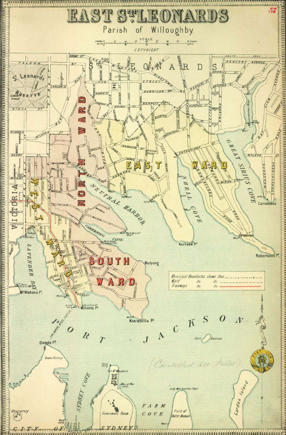
East St Leonards, parish of Willoughby
This map [media]shows the municipality of East St Leonards with its three wards at a scale of 1:11880 (1 inch equals 15 chains). It was probably published between 1889 and 1890.
East St Leonards was constituted in 1860 with an area of 2.4 square kilometres, which includes the modern suburbs of Kirribilli, Cremorne Point, Milsons Point and parts of Neutral Bay, Cremorne, Lavender Bay and North Sydney. In 1890 it, along with St Leonards and Victoria, became part of the new larger municipality of North Sydney. This is reflected in an annotation in pencil on the map which reads 'cancelled see index'.
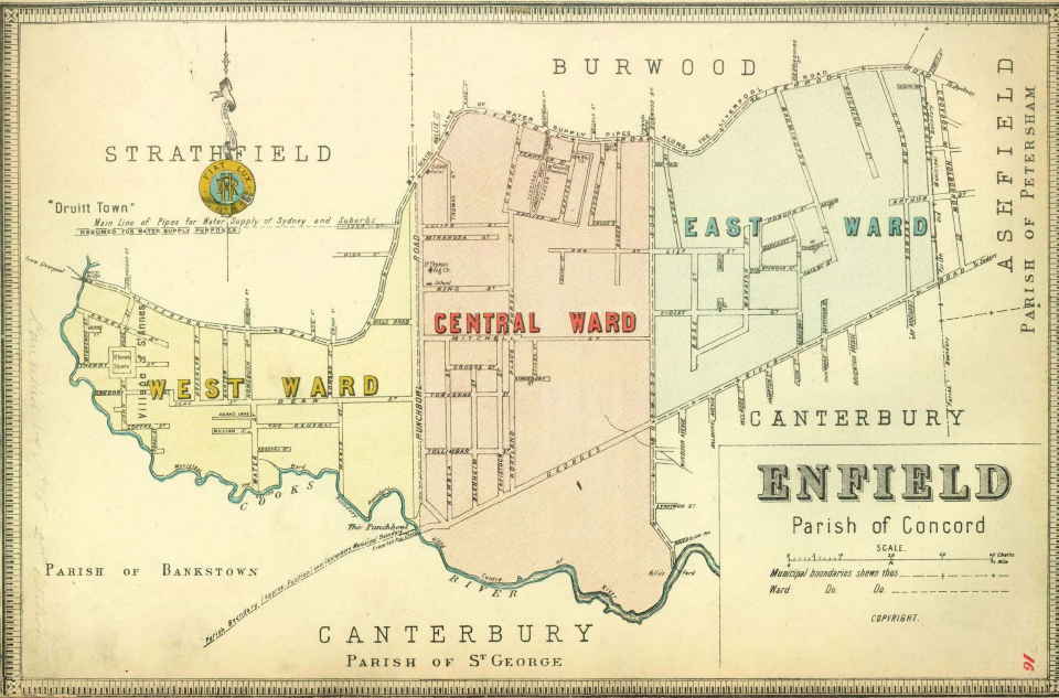
Enfield, parishes of Concord & Bankstown
This map shows [media]the municipality of Enfield with its three wards at a scale of 1:11880 (1 inch equals 15 chains). It was probably published between 1889 and 1894.
Enfield was constituted in 1889 with an area of 3.6 square kilometres, which includes the modern suburbs of Enfield, Burwood Heights and parts of Croydon, Croydon Park and Strathfield South. In 1948 Enfield was absorbed into the municipalities of Strathfield and Burwood.
Fivedock, parish of Concord
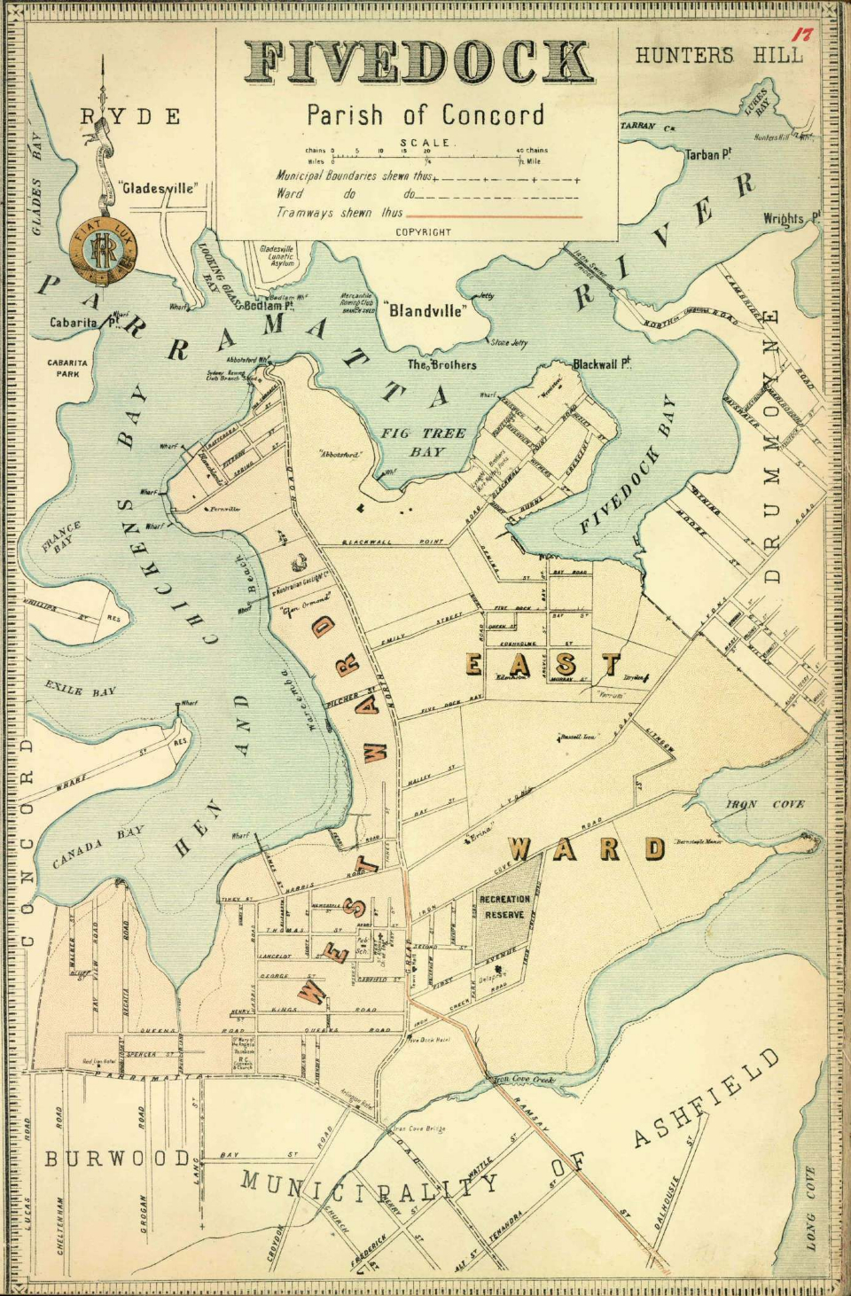
[media]This map shows the municipality of Fivedock with its two wards at a scale of 1:15840 (1 inch equals 20 chains). It was probably published between 1889 and 1894.
Fivedock was constituted in 1871 with an area of 6 square kilometres, which includes the modern suburbs of Five Dock, Abbotsford, Wareemba, Chiswick, Russell Lea, Rodd Point and Canada Bay. In 1902 Fivedock was absorbed by the municipality of Drummoyne.
The Glebe, parish of Petersham
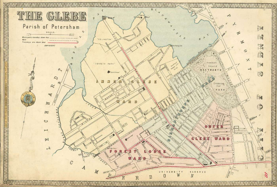
This [media]map shows the municipality of Glebe with its four wards at a scale of 1:7920 (1 inch equals 10 chains). It was probably published between 1886 and 1888.
Glebe was constituted in 1859 with an area of 2 square kilometres, which includes the modern suburbs of Glebe and Forest Lodge. In 1948 it was absorbed into the City of Sydney.
Granville, parishes of St John & Liberty Plains
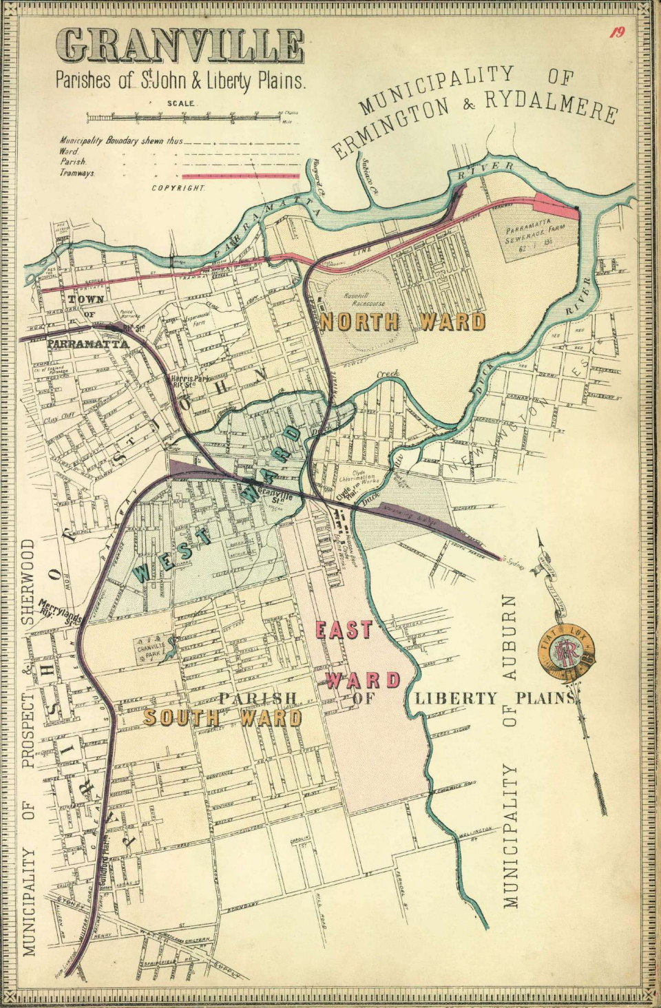
This map [media]shows the municipality of Granville with its four wards at a scale of 1:15840 (1 inch equals 20 chains). It was probably published between 1889 and 1894.
Granville was constituted in 1885 with an area of 12.4 square kilometres, which includes the modern suburbs of Granville, Camellia, Rosehill, Clyde and parts of Harris Park, Guildford and Merrylands. In 1948 it was absorbed by the municipality of Parramatta.
Hunters Hill, parish of Hunters Hill
This map shows [media]the municipality of Hunters Hill with its three wards at a scale of 1:7920 (1 inch equals 10 chains). It was probably published between 1889 and 1894.
Hunters Hill was constituted in 1861 with an area of 5.7 square kilometres, which includes the modern suburbs of Hunters Hill, Woolwich, Huntleys Point, Tarban, Henley and part of Gladesville. The municipality remains one of the smallest and least altered local government areas in Sydney.
Proposed municipality of Hurstville, parish of St George
[media]This map shows the proposed municipality of Hurstville at a scale of 1:39600 (1 inch equals 50 chains). It was probably published between 1886 and 1888. On this copy red ink has been used to cross out the word 'proposed' and to outline the municipal boundary. This overprinting effectively updates the map to March 1887.
Hurstville was constituted in 1887 with an area of 37.4 square kilometres, making it one of the largest Sydney municipalities. It included the modern suburbs of Hurstville, Bexley North, Peakhurst Heights, Lugarno, Peakhurst, Riverwood and parts of Kingsgrove, Bardwell Park, Kogarah, Carlton, Penshurst, Mortdale, Oatley, Narwee and Beverly Hills. The municipality became the City of Hurstville in 1988.
Kogarah, parish of St George
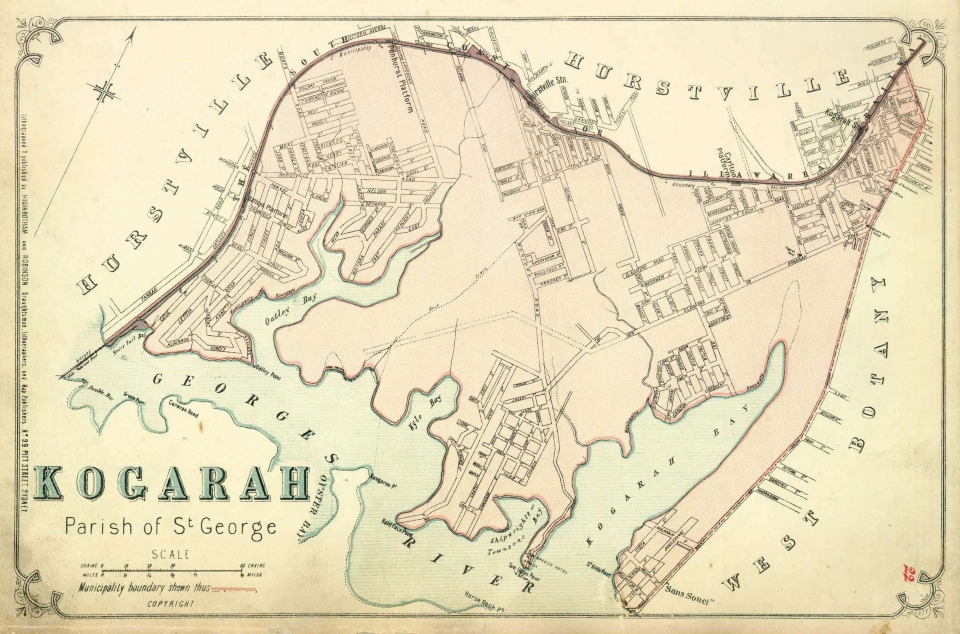
This [media]map shows the municipality of Kogarah at a scale of 1:23760 (1 inch equals 30 chains). It was probably published between 1886 and 1888.
Kogarah was constituted in 1885 with an area of 18.7 square kilometres, which includes the modern suburbs of Beverley Park, Kogarah Bay, Carss Park, Blakehurst, Kyle Bay, Connells Point, Hurstville Grove, South Hurstville, Allawah and parts of Kogarah, Sans Souci, Oatley, Mortdale, Penshurst, Hurstville and Carlton.
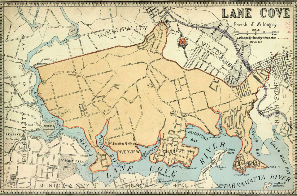
Lane Cove, parish of Willoughby
This map [media]shows the municipality of Lane Cove at a scale of 1:13464 (1 inch equals 17 approx chains). It was probably published about 1895.
Lane Cove was constituted in 1895 when it was separated from the municipality of Willoughby. It had an area of 10.3 square kilometres, which includes the modern suburbs of Lane Cove, Osborne Park, Greenwich, Northwood, Longueville, Riverview, Linley Point, Lane Cove West and parts of Lane Cove North and St Leonards.
Leichhardt, parish of Petersham
This is the [media]earlier of two maps of the municipality of Leichhardt showing it with four wards at a scale of 1:15840 (1 inch equals 20 chains). Although Leichhardt was included in the six maps that made up the first part of the Atlas, published in December 1885, this map was presumably reissued between 1886 and 1888.
Leichhardt was constituted in 1871 with an area of 6.3 square kilometres, which includes the modern suburbs of Leichhardt, Lilyfield and Annandale. In 1894 the East Ward became the separate municipality of Annandale.
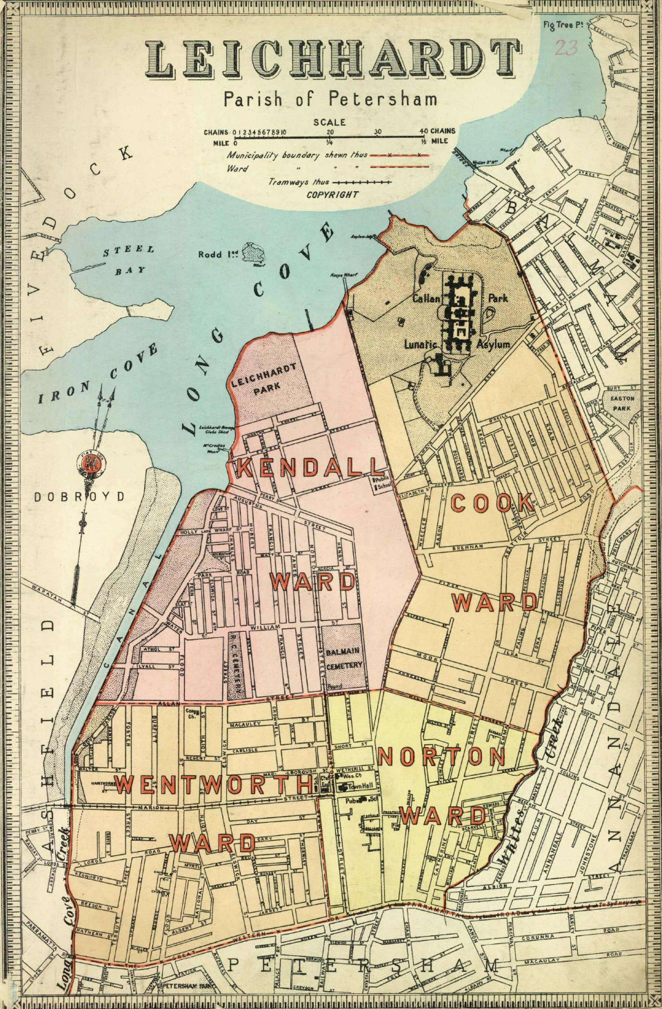
Leichhardt, parish of Petersham
This is the [media]later of two maps of the municipality of Leichhardt showing it with four wards at a scale of 1:15840 (1 inch equals 20 chains). It was probably published in 1894.
Leichhardt was constituted in 1871 and after the separation of Annandale in 1894 it had an area of 4.8 square kilometres, which includes the modern suburbs of Leichhardt and Lilyfield. In 1948 Leichhardt was considerably enlarged by its amalgamation with Annandale and Balmain.
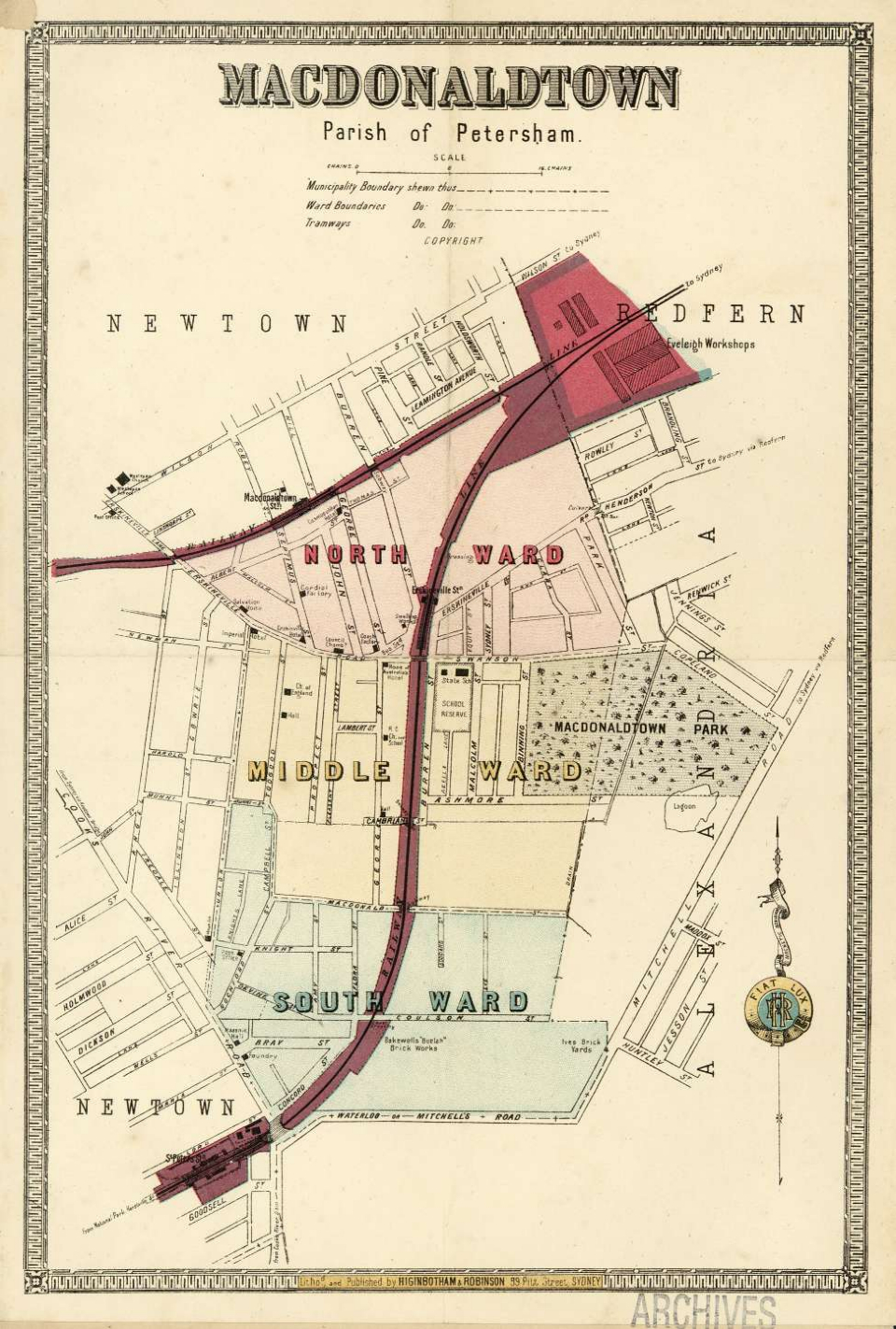
Macdonaldtown, parish of Petersham
[media]This map shows the municipality of Macdonaldtown with its three wards at a scale of 1:6336 (1 inch equals 8 chains). It was probably published between 1886 and 1888.
Macdonaldtown was constituted in 1872 with an area of 0.8 square kilometres, making it one of the smallest of the Sydney municipalities. It included the modern suburbs of Erskineville and part of Eveleigh. In 1893 the name of the municipality was changed to Erskineville and in 1948 it was absorbed by the City of Sydney.
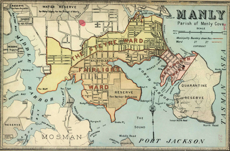
Manly, parish of Manly Cove
This [media]map shows the municipality of Manly with its three wards at a scale of 1:15840 (1 inch equals 20 chains). It was probably published between 1890 and 1894.
Manly was constituted in 1877 and divided into wards in 1890. It had an area of 12.8 square kilometres, which includes the modern suburbs of Manly, Balgowlah Heights, Clontarf, Balgowlah, Fairlight and part of Seaforth.
Marrickville, parish of Petersham
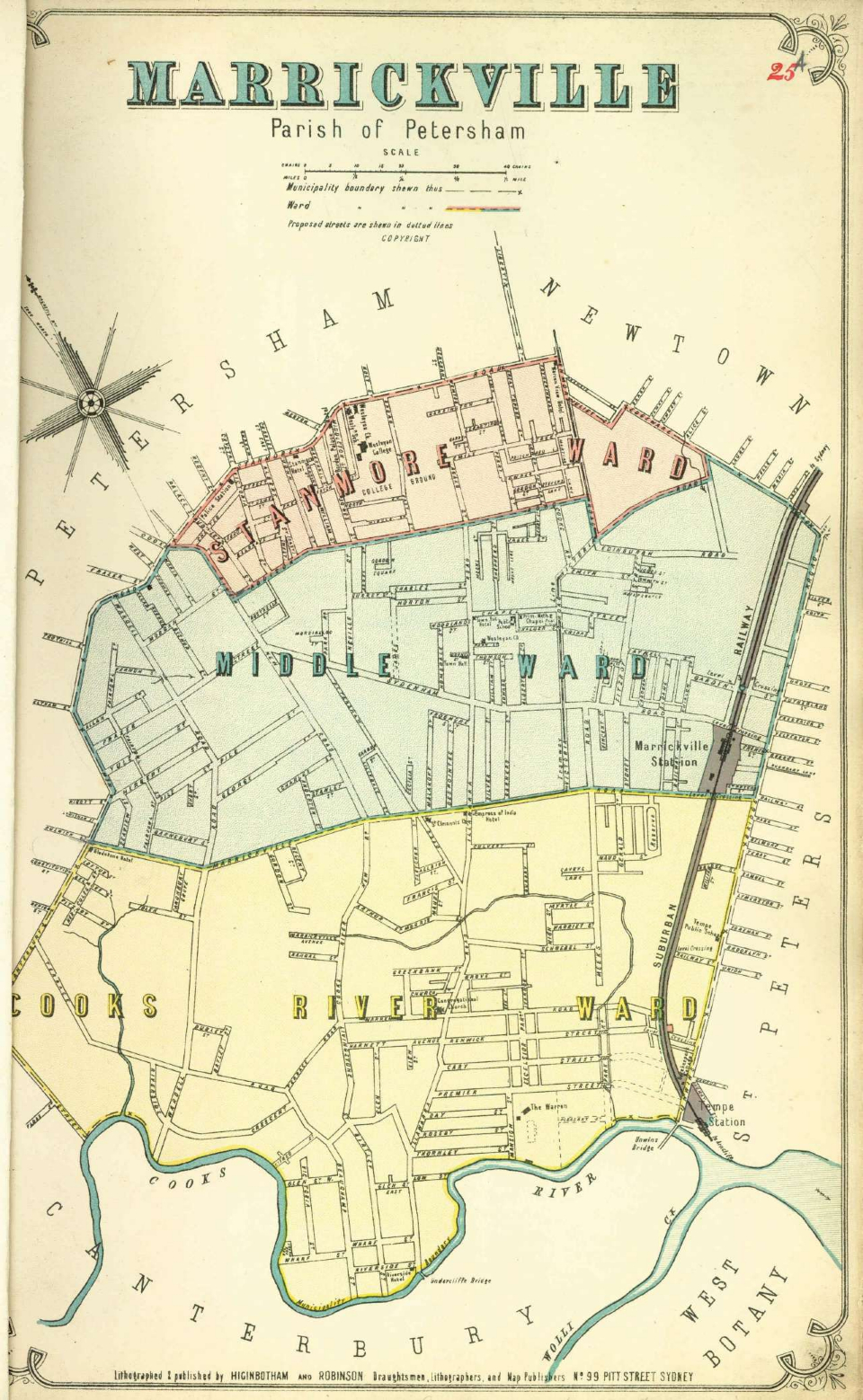
This is the [media]earlier of two maps of the municipality of Marrickville with three wards at a scale of 1:15840 (1 inch equals 20 chains). Although Marrickville was included in the six maps that made up the first part of the Atlas, published in December 1885, this map was presumably reissued between 1886 and 1888.
Marrickville was constituted in 1861 with an area of 8 square kilometres, which includes the modern suburb of Marrickville and parts of Petersham, Stanmore, Enmore, St Peters, Sydenham, Tempe, Dulwich Hill and Lewisham.
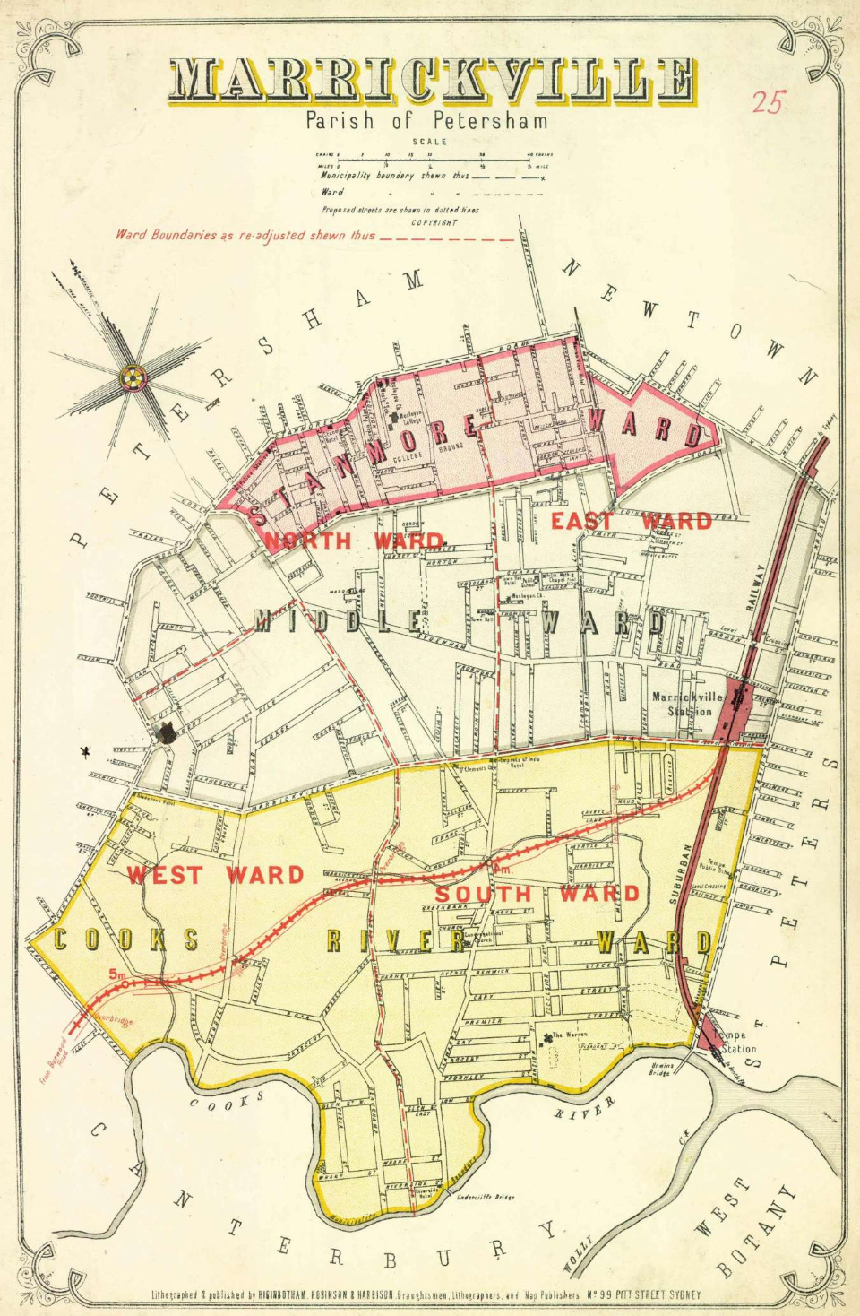
Marrickville, parish of Petersham
This is the [media]later version of two maps of the municipality of Marrickville, in this case showing four wards. The adjusted ward boundaries and the line of the Bankstown railway line have been overprinted in red ink to update the map. The date of this later version is not clear, although the railway line opened in early 1895. Paradoxically, this overprinted map is the only one in the set to have the company name listing the three partners, so this base map is from 1885 with the overprinting about a decade later.
Mosman, parish of Willoughby
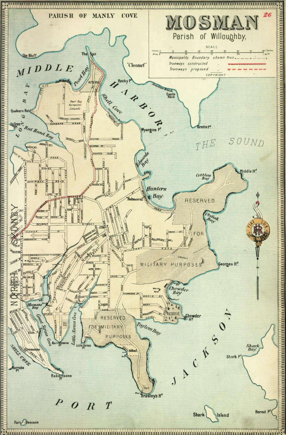
[media]This map shows the municipality of Mosman at a scale of 1:12672 (1 inch equals 16 chains). It was probably published between 1893 and 1894.
Mosman was constituted in 1893 with an area of 8.5 square kilometres, and corresponds with the modern suburb and municipality of the same name. It had originally been part of the large municipality of St Leonards established in 1867. This was replaced in 1890 by the new municipality of North Sydney and in 1893 Mosman separated from it.
Newtown, parish of Petersham
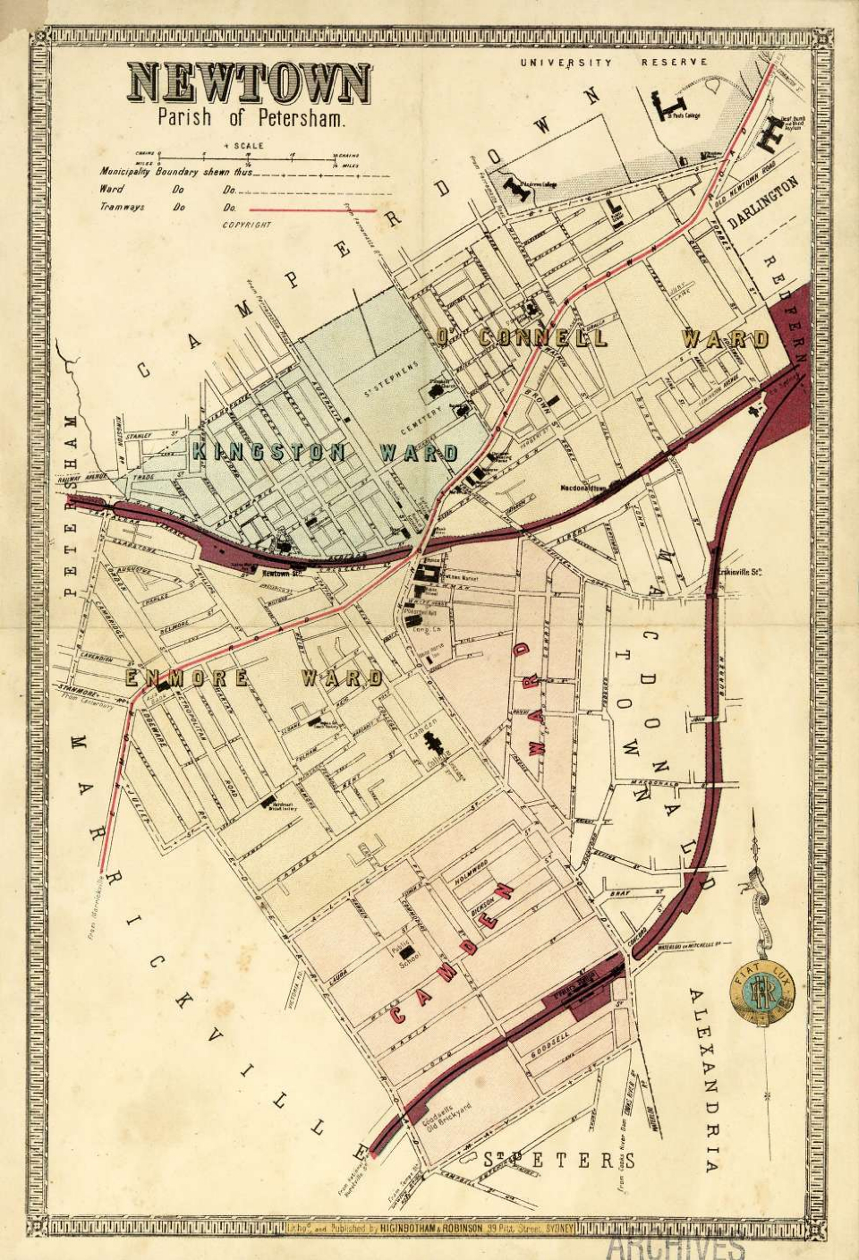
This [media]map shows the municipality of Newtown with its four wards at a scale of 1:7920 (1 inch equals 10 chains). It was probably published between 1886 and 1888.
Newtown was constituted in 1862 with an area of 1.9 square kilometres, which includes the modern suburbs of Newtown and parts of Camperdown, St Peters and Enmore. In 1948 Newtown was absorbed into the City of Sydney.
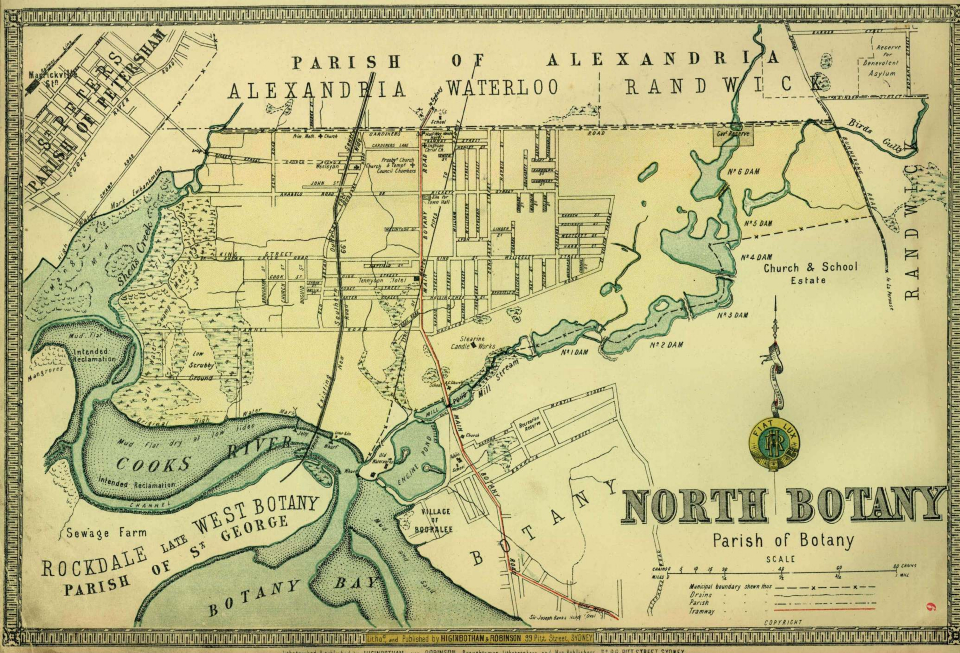
North Botany, parish of Botany
This map [media]shows the municipality of North Botany at a scale of 1:19800 (1 inch equals 25 approx chains). It was probably published about 1888.
North Botany was constituted in 1888 with an area of 9 square kilometres, which includes the modern suburbs of Eastlakes, Daceyville and parts of Mascot and Pagewood. North Botany became the major part of the new municipality of Mascot in 1911 and in 1948 Mascot was amalgamated with Botany.
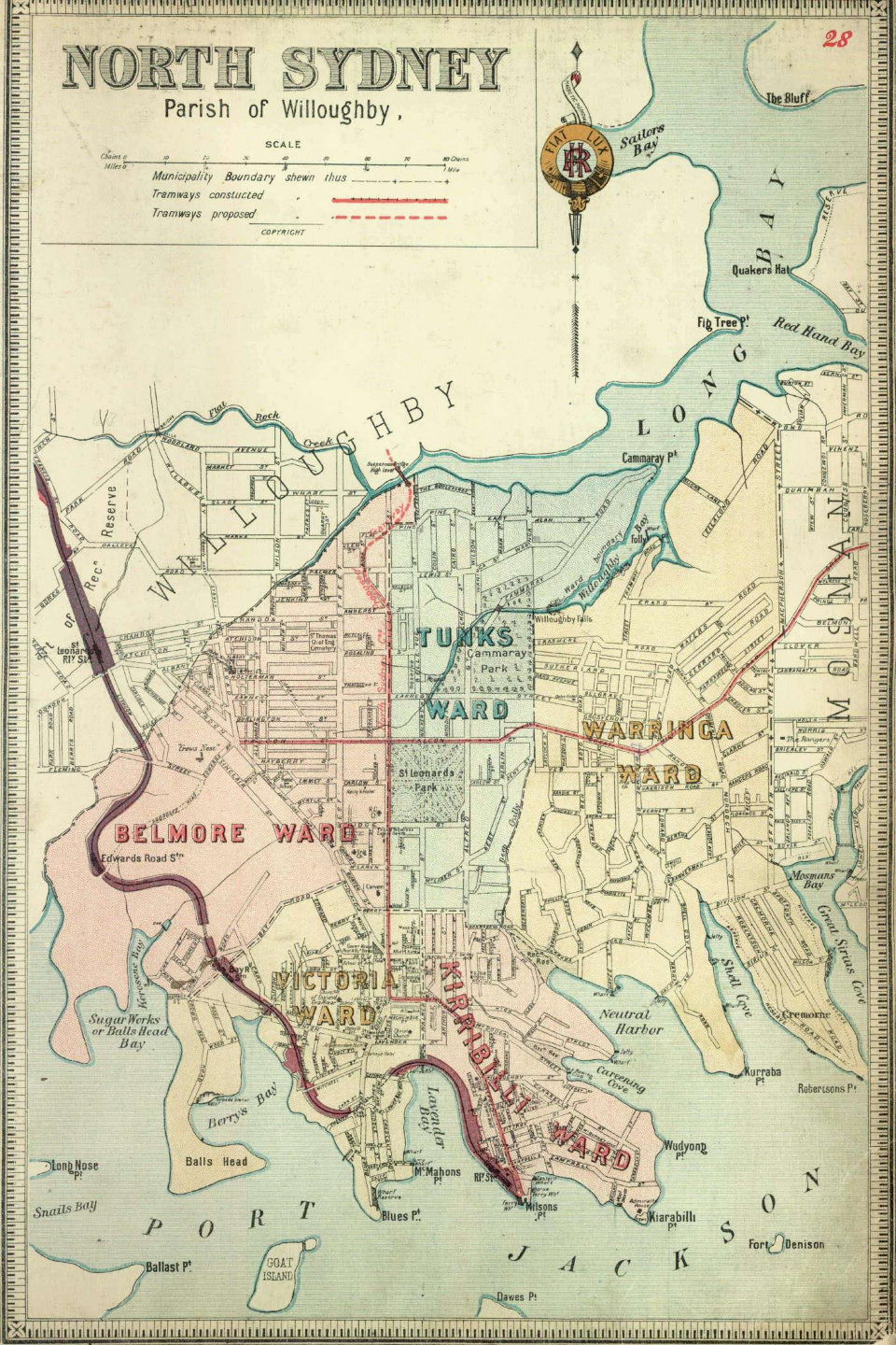
North Sydney, parish of Willoughby
This map shows [media]the municipality of North Sydney with its five wards at a scale of 1:12672 (1 inch equals 16 chains). It was probably published about 1893.
North Sydney was created in 1890 by the amalgamation of the municipalities of St Leonards, East St Leonards and Victoria, but in 1893 Mosman separated and became an independent municipality. North Sydney is shown here as constituted in 1893 with an area of 10.3 square kilometres, which includes the modern suburbs of North Sydney, Cammeray, Cremorne, Cremorne Point, Neutral Bay, Kirribilli, Milsons Point, Lavender Bay, McMahons Point, Waverton, Wollstonecraft and parts of Crows Nest.
Paddington, parish of Alexandria
[media]This map shows the municipality of Paddington with its four wards at a scale of 1:7920 (1 inch equals 10 chains). It was probably published between 1886 and 1888.
Paddington was constituted in 1860 with an area of 1.7 square kilometres, which includes the modern suburb of Paddington and parts of Edgecliff. Paddington was absorbed into the City of Sydney in 1948.
Parramatta, parishes of St John & Field of Mars
This [media]map shows the municipality of Parramatta with its four wards at a scale of 1:11880 (1 inch equals 15 approx chains). It was probably published between 1889 and 1894.
Parramatta was constituted in 1861 with an area of 9.1 square kilometres, which includes the modern suburbs of Parramatta and North Parramatta and parts of Harris Park, Westmead and Northmead.
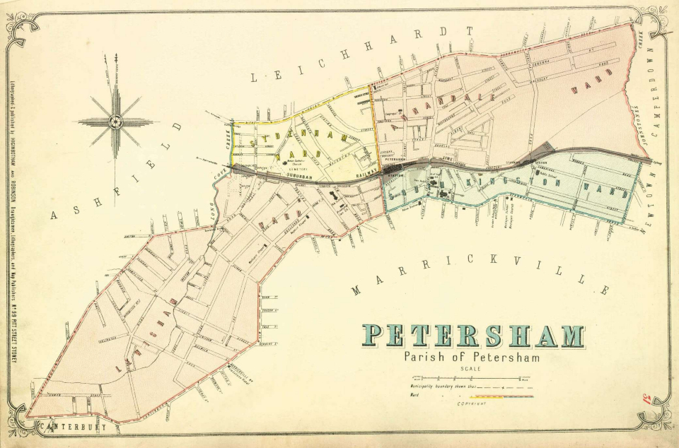
Petersham, parish of Petersham
This map [media]shows the municipality of Petersham with its four wards at a scale of 1:7920 (1 inch equals 10 chains). Although Petersham was included in the six maps that made up the first part of the Atlas, published in December 1885, this map was presumably reissued between 1886 and 1888.
Petersham was constituted in 1871 with an area of 3.5 square kilometres, which includes parts of the modern suburbs of Petersham, Stanmore, Dulwich Hill and Lewisham. In 1948 Petersham was amalgamated with Marrickville.
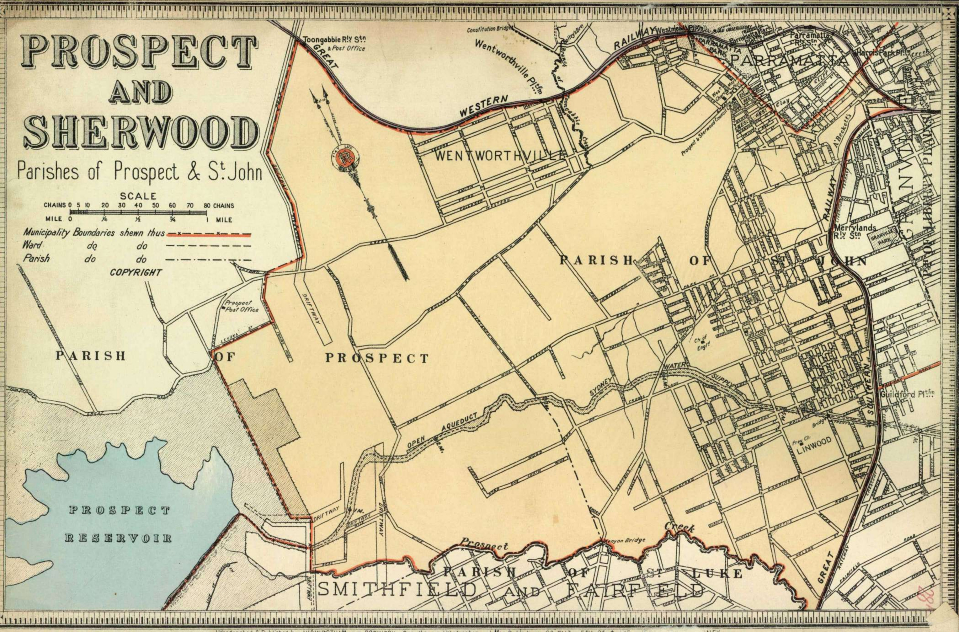
Prospect & Sherwood, parishes of Prospect & St John
This map shows [media]the municipality of Prospect and Sherwood at a scale of 1:31680 (1 inch equals 40 chains). It was probably published between 1889 and 1894.
Prospect and Sherwood was constituted in 1872 with an area of 39.9 square kilometers, making it one of the largest municipalities in Sydney. The area included the modern suburbs of Girraween, Greystanes, South Wentworthville, Mays Hill, Holroyd, Merrylands West, Guildford West, Woodpark and parts of Pendle Hill, Wentworthville, Westmead, Granville, Merrylands, Guildford, Yennora, Smithfield and Prospect. In 1927 Prospect and Sherwood was renamed Holroyd municipality,
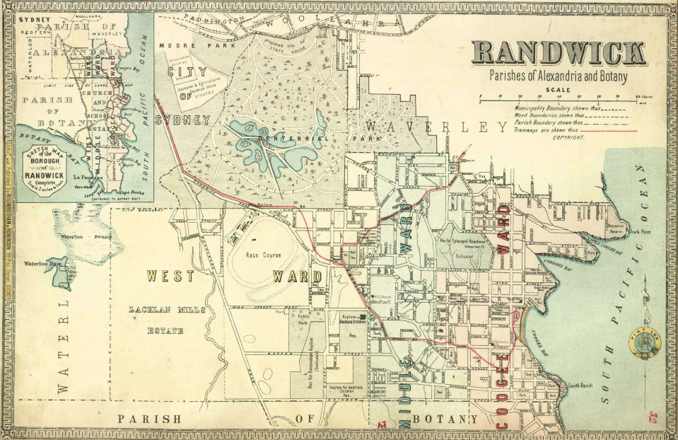
Randwick, parishes of Alexandria and Botany
[media]This map shows the municipality of Randwick with its three wards. The main section of the map is at a scale of 1:19800 (1 inch equals 25 chains). The map includes an inset which shows the southern part of the municipality at a scale of 1:126720 (1 inch equals 2 miles). It was probably published between 1886 and 1888.
Randwick was constituted in 1859 with an area of 30.5 square kilometres, which includes the modern suburbs of Randwick, Centennial Park, Clovelly, Coogee, South Coogee, Malabar, Chifley, Little Bay, La Perouse, Phillip Bay and parts of Queens Park, Maroubra, Matraville, Kingsford and Kensington.
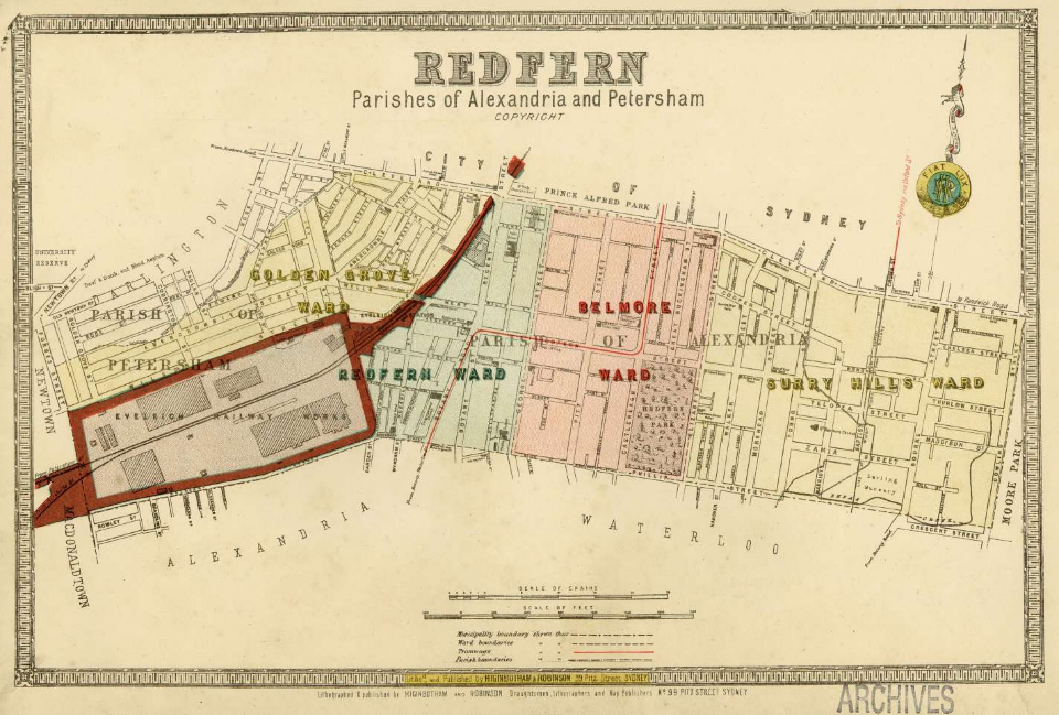
Redfern, parishes of Alexandria and Petersham
This [media]map shows the municipality of Redfern with its four wards at a scale of 1:7920 (1 inch equals 10 chains). It was probably published between 1886 and 1888.
Redfern was constituted in 1859 with an area of 1.7 square kilometres, which includes the modern suburb of Redfern and parts of Darlington and Eveleigh. In 1948 it was it was absorbed into the City of Sydney.
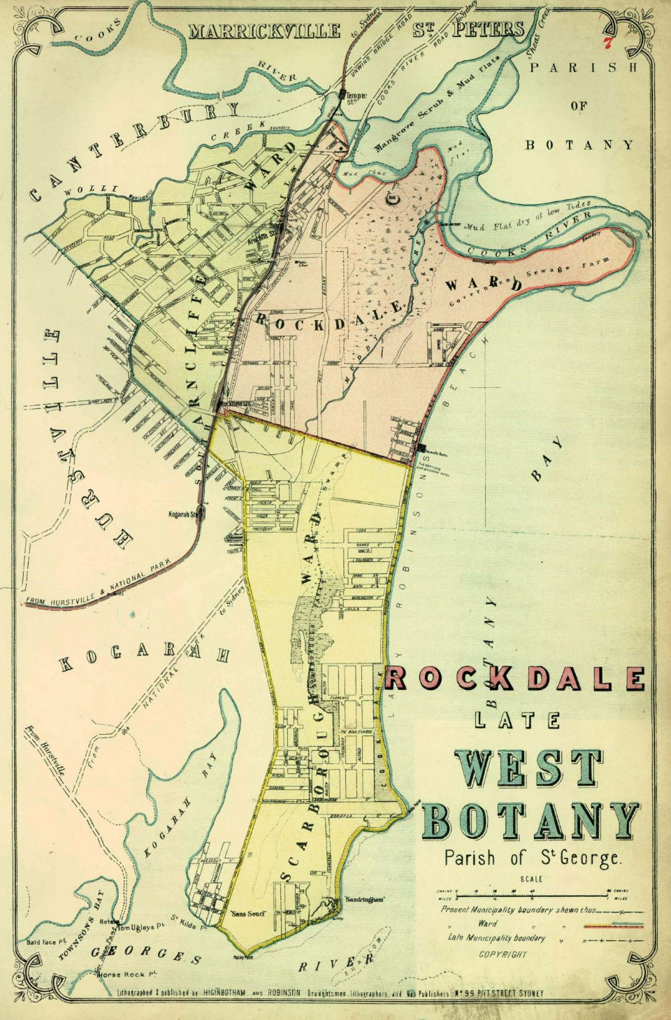
Rockdale late West Botany, parish of St George
This map [media]shows the municipality of Rockdale with its three wards at a scale of 1:31680 (1 inch equals 40 chains). It was probably published in 1888.
The municipality was constituted as Botany West in 1871 and renamed Rockdale in 1888. It had an area of 19.8 square kilometres, which includes the modern suburbs of Rockdale, Turrella, Arncliffe, Banksia, Kyeemagh, Brighton-Le-Sands, Monterey, Dolls Point, Sandringham and parts of Mascot, Sans Souci, Bardwell Valley and Bardwell Park.
Rookwood, parishes of Liberty Plains, Concord and Saint John
This map shows [media]the municipality of Rookwood at a scale of 1:23760 (1 inch equals 30 chains). It was probably published between 1891 and 1894.
Rookwood was constituted in 1891 with an area of 22.3 square kilometres, which includes the modern suburbs of Rookwood, Newington, Homebush Bay, Lidcombe, Berala and parts of Silverwater, Homebush West and Regents Park. In 1913 Rookwood was renamed Lidcombe, largely to separate the identity of the municipality from the necropolis.
Ryde & Marsfield, parishes of Hunters and Hill & Field of Mars
[media]This map shows the municipality of Ryde with its three wards at a scale of 1:39600 (1 inch equals 50 chains). It was originally published between 1889 and 1894, but this version with Marsfield overprinted must be after 1894.
Ryde was constituted in 1870 with an area of 40.6 square kilometres making it the largest Sydney municipality. The area included the modern suburbs of Ryde, Marsfield, Macquarie Park, North Ryde, East Ryde, Tennyson, Putney, Meadowbank, West Ryde, Denistone West, Denistone, Denistone East and parts of Gladesville, Melrose Park and Eastwood. In 1894 Marsfield seceded to form its own municipality.
St Leonards, parish of Willoughby
This [media]map shows the municipality of St Leonards with its four wards at a scale of 1:27720 (1 inch equals 35 chains). It was probably published between 1889 and 1890.
St Leonards was constituted in 1867 with an area of 15.8 square kilometres, which includes the modern suburbs of Cammeray, Mosman, Waverton, Wollstonecraft and parts of Cremorne, Neutral Bay, North Sydney and Crows Nest. In 1890 the municipalities of St Leonards, East St Leonards and Victoria merged to form the municipality of North Sydney and three years later Mosman became a separate municipality.
St Peters, parish of Petersham
This map [media]shows the municipality of St Peters with its three wards at a scale of 1:11880 (1 inch equals 15 chains). Although St Peters was included in the six maps that made up the first part of the Atlas, published in December 1885, this map was presumably reissued between 1886 and 1888.
St Peters was constituted in 1871 with an area of 3.1 square kilometres, which includes parts of the modern suburbs of St Peters, Tempe and Sydenham. In 1948 St Peters was amalgamated with Marrickville.
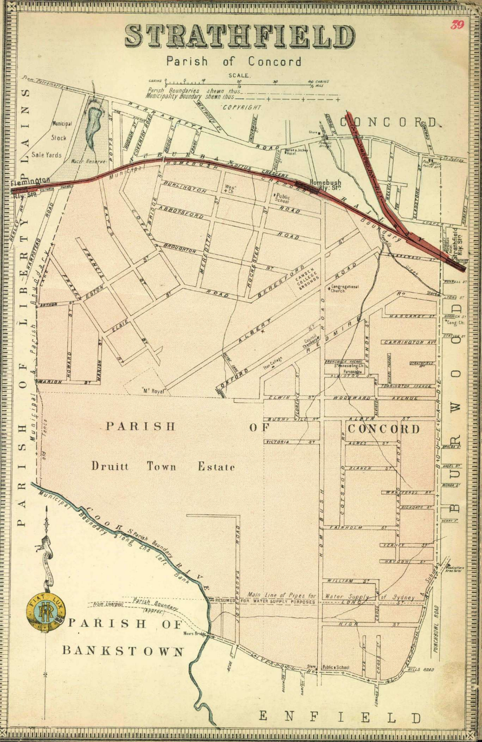
Strathfield, parish of Concord
This map shows [media]the municipality of Strathfield at a scale of 1:11880 (1 inch equals 15 approx chains). It was probably published between 1889 and 1894.
Strathfield was constituted in 1885 with an area of 5.6 square kilometres, which includes parts of the modern suburbs of Strathfield, Homebush and Homebush West.
Sydney, parishes of St Phillip, St James, St Andrew, St Lawrence & Alexandria
[media]This map shows the municipality of Sydney with its eight wards at a scale of 1:19800 (1 inch equals 25 chains). It was probably published between 1889 and 1894.
Sydney was constituted in 1842; this map shows it as it was after 1870 when it incorporated the area of Moore Park. It had an area of 11.2 square kilometres, which included the modern suburbs of Sydney, Woolloomooloo, Potts Point, Elizabeth Bay, Rushcutters Bay, Darlinghurst, Surry Hills, Moore Park, Chippendale, Haymarket, Ultimo, Pyrmont, Millers Point, Dawes Point and The Rocks.
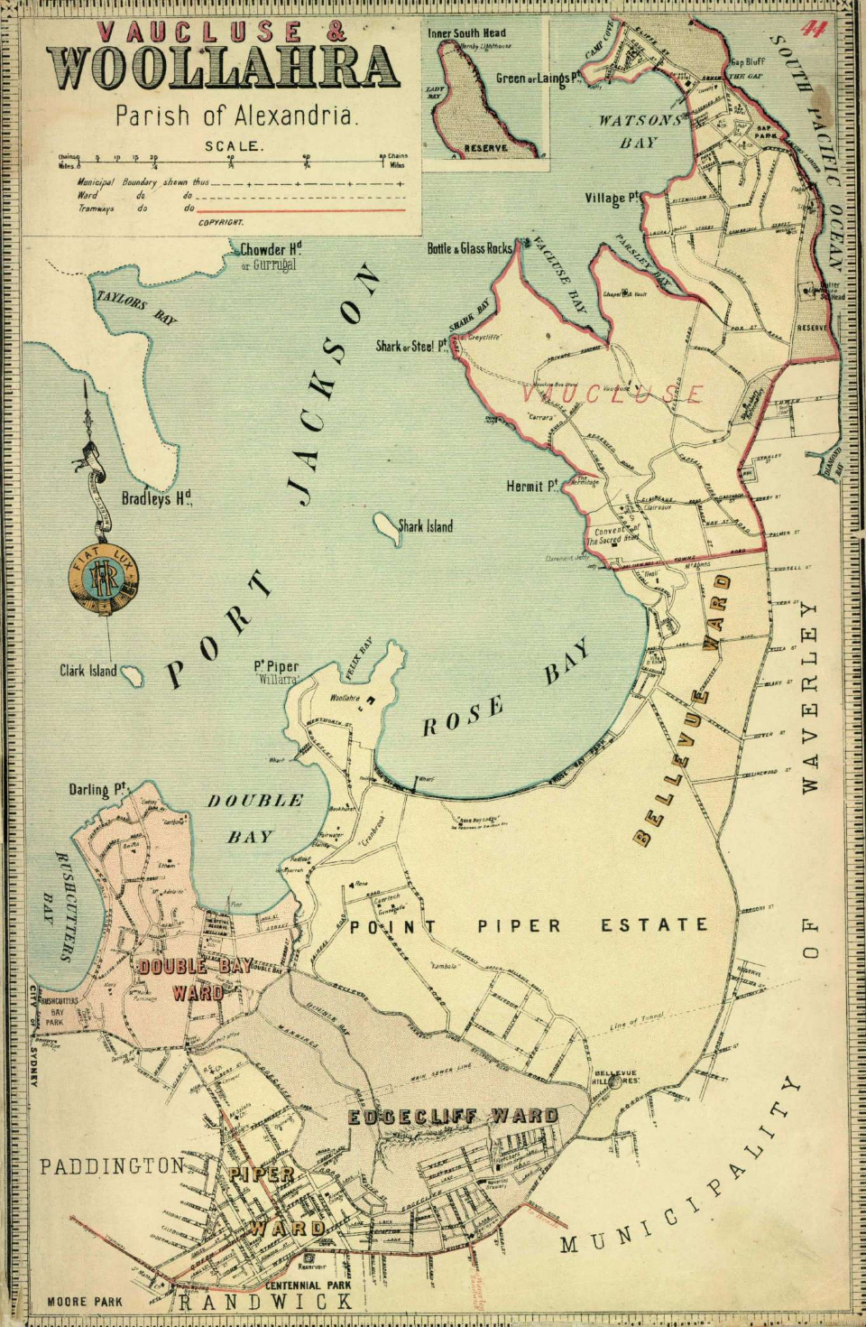
Vaucluse & Woollahra, parish of Alexandria
This [media]map shows the municipality of Woollahra with its four wards at a scale of 1:19800 (1 inch equals 25 chains). It was probably originally published between 1889 and 1894 but this version, with the municipality of Vaucluse overprinted, presumably dates from 1895 or after.
Woollahra was constituted in 1860 with an area of 10.3 square kilometres, which includes the modern suburbs of Woollahra, Bellevue Hill, Double Bay, Darling Point and parts of Vaucluse, Rose Bay and Edgecliff. Vaucluse was created as a separate municipality in 1895.
Victoria, parish of Willoughby
This map [media]shows the municipality of Victoria at a scale of 1:6336 (1 inch equals 8 chains). It was probably published between 1889 and 1890.
Victoria was constituted in 1871 with an area of 0.7 square kilometres, making it one of the smallest Sydney municipalities. It included the modern suburb of McMahons Point and parts of North Sydney and Lavender Bay. In 1890 the municipalities of Victoria, St Leonards and East St Leonards merged to form the municipality of North Sydney.
Waterloo, parish of Alexandria
This map shows [media]the municipality of Waterloo at a scale of 1:11880 (1 inch equals 15 chains). It was probably published between 1886 and 1888.
Waterloo was constituted in 1860 with an area of 3.4 square kilometres, which includes the modern suburbs of Waterloo, Zetland and Rosebery. In 1948 Waterloo was amalgamated with the City of Sydney.
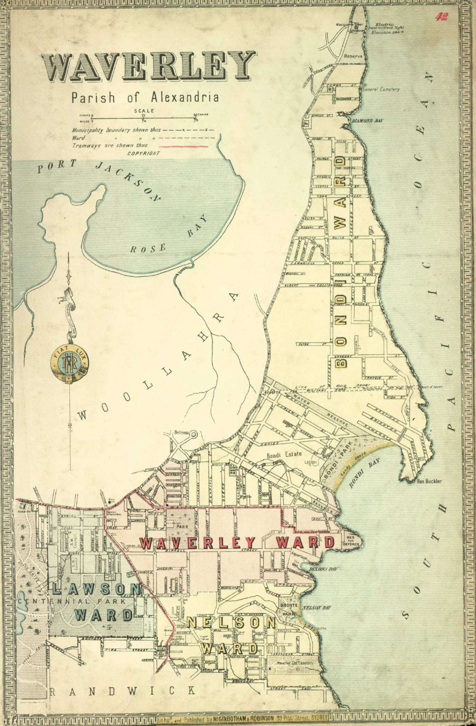
Waverley, parish of Alexandria
[media]This map shows the municipality of Waverley with its four wards at a scale of 1:13464 (1 inch equals 17 approx chains). It was probably published between 1886 and 1888.
Waverley was constituted in 1859 with an area of 9.1 square kilometres, which includes the modern suburbs of Waverley, Dover Heights, North Bondi, Bondi Beach, Bondi, Tamarama, Bronte and parts of Vaucluse, Rose Bay, Queens Park and Bondi Junction.
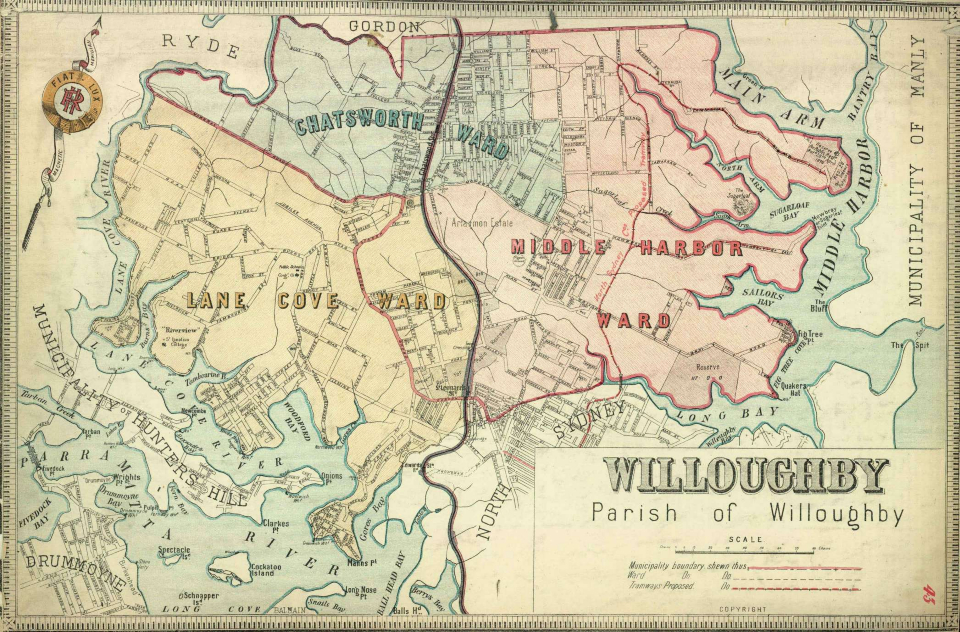
Willoughby, parish of Willoughby
This [media]map shows the municipality of Willoughby with its three wards at a scale of 1:21384 (1 inch equals approximately 27 chains). It was probably published between 1890 and 1894.
Willoughby was constituted in 1865 as North Willoughby. It had an area of 32.7 square kilometres, which includes the modern suburbs of Willoughby, Castle Cove, Middle Cove, North Willoughby, Willoughby East, Castlecrag, Northbridge, Naremburn, St Leonards, Artarmon, Greenwich, Northwood, Osborne Park, Longueville, Riverview, Linley Point, Lane Cove, Lane Cove West, Lane Cove North, Chatswood West, Chatswood and parts of Roseville. In 1890 its name was changed to Willoughby and in 1895 Lane Cove municipality was separated from it.
References
DB Lambley, A key to the historical geography of local government areas in New South Wales, Geographical Society of New South Wales and the New South Wales Department of Local Government, Sydney, 1989
GP Walsh, 'Robinson, Herbert Edward Cooper (1857–1933)', Australian Dictionary of Biography, vol 11, 1988, National Centre of Biography, Australian National University, http://adb.anu.edu.au/biography/robinson-herbert-edward-cooper-1320/text14433, viewed 16 May 2012
Notes
[1] 'NEWS OF THE DAY', Sydney Morning Herald, 26 August 1882, p 11, available online at http://nla.gov.au/nla.news-article13521867
[2] 'NEWS OF THE DAY', Sydney Morning Herald, 22 December 1885, p 7, available online at http://nla.gov.au/nla.news-article13607258
[3] Atlas of the Suburbs of Sydney, Part 2, State Library of New South Wales, Mitchell Library Maps/1148
[4] 'Advertising', Sydney Morning Herald, 4 May 1888, p 14, available online at http://nla.gov.au/nla.news-article28341837
[5] Historical Atlas of Sydney, City of Sydney Archives website, http://www.photosau.com.au/CoSMaps/scripts/home.asp, viewed 15 May 2012
[6] Personal communication, Mark Steven, City of Sydney Archivist, 15 May 2012
.


